 |
Home Search OKRoads: |
|
|
Home Search OKRoads: |
Interstate 90 New York
Westbound - Interstate
790 to Interstate 490 West
|
Highway Information |
|
| Miles | 385.48 |
| Counties Traveled Through |
Chautauqua, Erie, Genesee, Monroe, Ontario, Seneca, Cayuga, Onondaga, Madison, Oneida, Herkimer, Montgomery, Schenectady, Albany, Rensselaer, Columbia |
| Cities |
Dunkirk, Buffalo, Batavia, Rochester, Syracuse, Oneida, Utica, Amsterdam, Schenectady, Albany |
| Major Junctions |
Interstate 190 (Exit 53)
Interstate 290 Interstate 490 Interstate 390 Interstate 690 Interstate 81 Interstate 481 Interstate 790 Interstate 890 Interstate 88 Interstate 87 |
| OKRoads Coverage | |
| Miles Driven by OKRoads (Percentage) |
379 (98%) |
| Western End of Interstate Driven |
Pennsylvania State Line |
| Eastern End of Interstate Driven |
Massachusetts State Line |
| Have Not Driven | Between Interstate 87 and Interstate 787 |
Pictures
Westbound:
Massachusetts State Line to Interstate 787
Interstate 87 to Interstate 790
Interstate 790 to Interstate 490 West
Interstate 490 West to U.S. 219
U.S. 219 to Pennsylvania State Line
| Interstate 90 West | |
 |
Interstate 90 West approaching Exit 32 - New York 233 - 1 mile. The state highway is 12 miles long and connects New York 12B in Franklin to New York 49 and New York 69 in Rome. (Photo taken 7/10/05) |
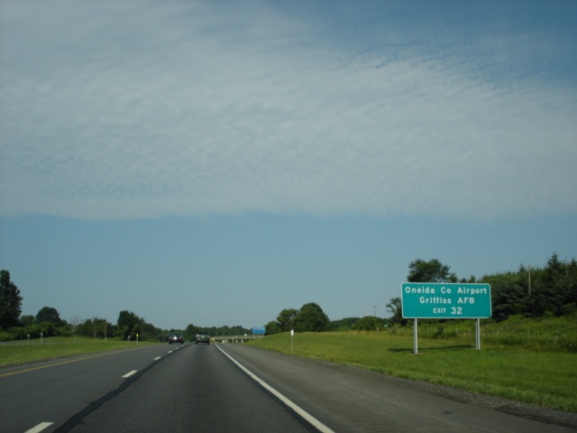 |
Use New York 233 northbound to the Oneida County Airport and Griffiss Air Force Base. (Photo taken 7/10/05) |
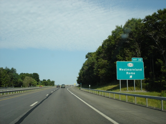 |
Interstate 90 West at Exit 32 - New York 233 - Westmoreland/Rome. Rome is five miles to the north. (Photo taken 7/10/05) |
 |
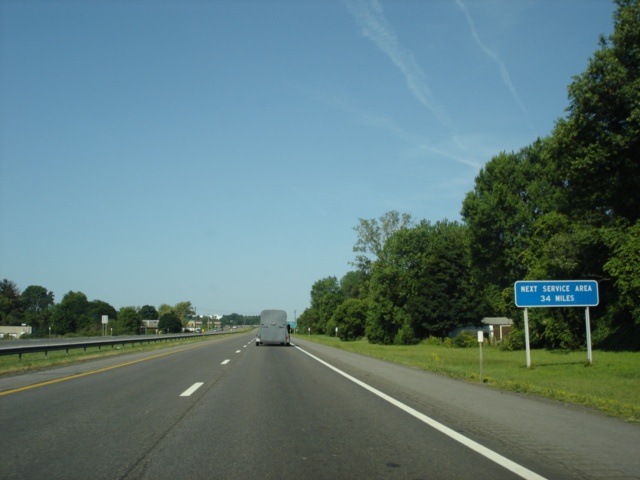
The next service area is the Chittenango service area in 22 miles. It includes a Sbarro and a Dunkin' Donuts. (Photo taken 7/10/05) |
 |
Interstate 90 West approaching Exit 33 - New York 365 - 1 mile. New York 365 connects New York 5 in Oneida to New York 8 near Wilmurt. The city of Oneida (pop. 10,987) is six miles to the southwest. (Photo taken 7/10/05) |
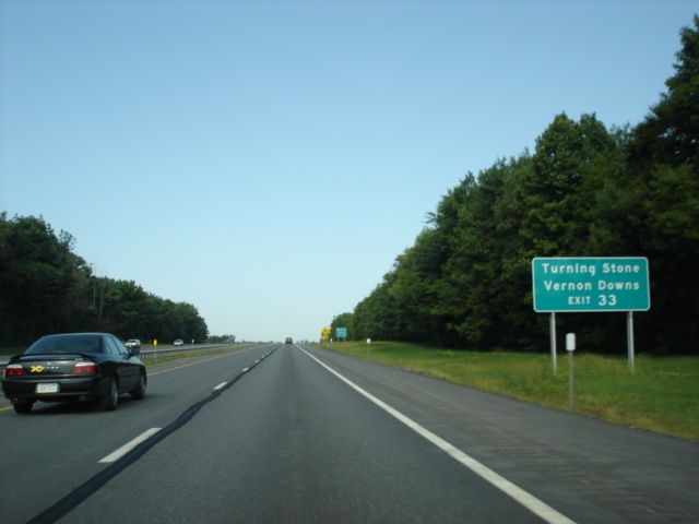 |
Use Exit 33 to the Turning Stone Resort and the Vernon Downs horse racing track. (Photo taken 7/10/05) |
 |
Hamilton is 25 miles to the south of Exit 33 via New York 365, New York 46, and New York 12B. Vernon is six miles to the southeast at the intersection of New York 5 and New York 31. (Photo taken 7/10/05) |
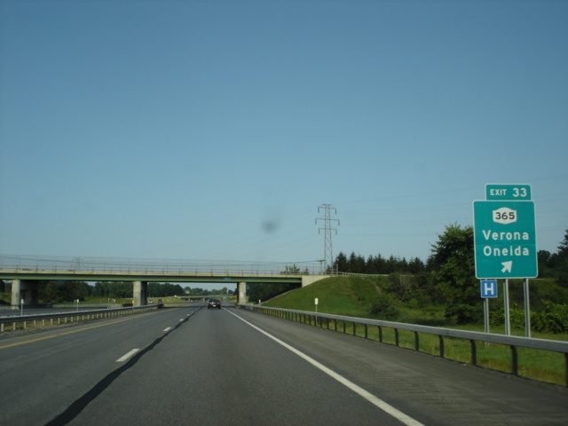 |
Interstate 90 West at Exit 33 - New York 365 - Verona/Oneida. (Photo taken 7/10/05) |
 |
Interstate 90 West approaching a parking area - 1 mile. As with the other parking areas along the Thruway, there are no restroom facilities available. (Photo taken 7/10/05) |
 |
The next service area is 11 miles ahead. (Photo taken 7/10/05) |
 |
Interstate 90 West at the parking area near the Oneida-Madison county line. (Photo taken 7/10/05) |
 |
Interstate 90 West approaching the Chittenango service area - 8 miles. (Photo taken 7/10/05) |
 |
Interstate 90 West approaching Exit 34 - New York 13 - 1 mile. The state highway travels from New York 17 in Horseheads to New York 3 in Port Ontario. It travels through Ithaca and Cortland along the way. (Photo taken 7/10/05) |
 |
Use New York 13 southbound for 16 miles to the town of Cazenovia. Head north on the state highway for nine miles to Sylvan Beach, located at the eastern edge of Oneida Lake. (Photo taken 7/10/05) |
 |
Interstate 90 West at Exit 34 - New York 13 - Canastota/Chittenango. Chittenango is at the western end of the New York 5/New York 13 duplex and is nine miles to the southwest. (Photo taken 7/10/05) |
 |
Interstate 90 West approaching the Chittenango service area - 2 miles. (Photo taken 7/10/05) |
 |
The next service area is 27 miles ahead in Onondaga County just west of Interstate 690 (Exit 39). (Photo taken 7/10/05) |
 |
Interstate 90 West approaching the Chittenango service area - 1 1/2 miles. (Photo taken 7/10/05) |
 |
Interstate 90 West approaching the Chittenango service area - 1 mile. (Photo taken 7/10/05) |
 |
Interstate 90 West approaching the Chittenango service area - 1/4 mile. (Photo taken 7/10/05) |
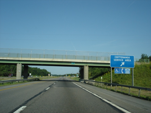 |
Interstate 90 West at the Chittenango service area. (Photo taken 7/10/05) |
 |
Interstate 90 West as it enters the city of Syracuse. Home to Syracuse University and 147,306 residents, it is the 5th largest city in the state. Six exits serve the city from the Thruway. (Photo taken 7/10/05) |
 |
Exit 34A (Interstate 481) through Exit 46 (Interstate 390) of the Thruway serve the Finger Lakes region of Upstate New York. The area encompasses 14 counties. (Photo taken 7/10/05) |
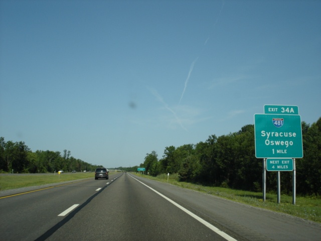 |
Interstate 90 West approaching Exit 34A - Interstate 481 - 1 mile. Interstate 481 provides a north-south bypass of Syracuse for Interstate 81 traffic. Interstate 81 heads directly through downtown Syracuse. Interstate 481 also makes up the eastern terminus of Interstate 690. (Photo taken 7/10/05) |
 |
Use Interstate 481 South to Interstate 690 West to the New York State Fairgrounds. Cortland is located on Interstate 81 and is 40 miles to the south. (Photo taken 7/10/05) |
 |
Interstate 90 West at Exit 34A - Interstate 481 - Syracuse/Oswego. Interstate 481 continues as New York 481 from the interstate's northern terminus at Interstate 81 and enters Oswego 39 miles to the northwest of this interchange, and 32 miles from the northern terminus of Interstate 481. (Photo taken 7/10/05) |
 |
Interstate 90 West approaching Exit 35 - New York 298 - 1 1/2 miles. New York 298 travels through the northern and western edges of Syracuse and is carried along Court Street and Carrier Parkway through the city. (Photo taken 7/10/05) |
 |
Interstate 90 West at Exit 35 - New York 298 - Syracuse/East Syracuse. Use New York 635 South to the village of East Syracuse. New York 635 begins at the Carrier Circle, which connects the Exit 35 off-ramp, New York 298, New York 635, Thompson Road, and Court Street Road. (Photo taken 7/10/05) |
 |
The Warners service plaza is 12 miles ahead, which is just past Exit 39 (Interstate 690). (Photo taken 7/10/05) |
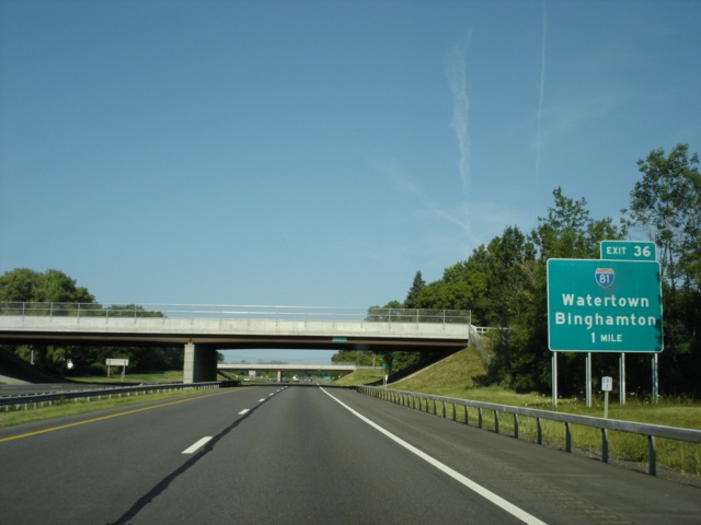 |
Interstate 90 West approaching Exit 36 - Interstate 81 - 1 mile. Interstate 81 provides the main north-south route through central New York, connecting Binghamton, Cortland, Syracuse, and Watertown. (Photo taken 7/10/05) |
 |
Use Interstate 81 North to Exit 27 to the Syracuse-Hancock International Airport. (Photo taken 7/10/05) |
 |
Use Interstate 81 South to Cortland and Ithaca. Pick up New York 13 in Cortland for the final 25 miles of the 60-mile drive from the Thruway to Ithaca. (Photo taken 7/10/05) |
 |
Interstate 90 West at Exit 36 - Interstate 81 - Watertown/Binghamton. Watertown is 67 miles to the north, and Binghamton is 78 miles to the south. Interstate 81 crosses the thruway on the overpasses just behind the sign. (Photo taken 7/10/05) |
 |
Interstate 90 West approaching Exit 37 - Electronics Parkway - 1/2 mile. This sign is original button-copy. Buckley Road passes over the Thruway here. Buckley Road is well-known by many Independent, Fundamental Baptists, because of the Buckley Road Baptist Church located on the arterial. (Photo taken 7/10/05) |
 |
Interstate 90 West at Exit 37 - Electronics Parkway/Liverpool. The village of Liverpool is home to 2,505 people. (Photo taken 7/10/05) |
 |
Interstate 90 West approaching Exit 38 - Onondaga County 57 - 1 mile. This is a rare case where a county route pentagon appears on a BGS on the Thruway. (Photo taken 7/10/05) |
 |
Use Onondaga County 57 north to Fulton and Oswego. The county route marks the western end of the New York 481 freeway in southeast Fulton. (Photo taken 7/10/05) |
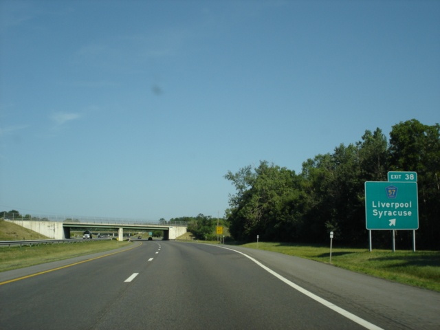 |
Interstate 90 West at Exit 38 - Onondaga County 57 - Liverpool/Syracuse. (Photo taken 7/10/05) |
 |
Interstate 90 West approaching the Warners service plaza - 4 miles. Onondaga Lake is just to the left (south) of this view. (Photo taken 7/10/05) |
 |
The next service area is 34 miles ahead in Seneca County. (Photo taken 7/10/05) |
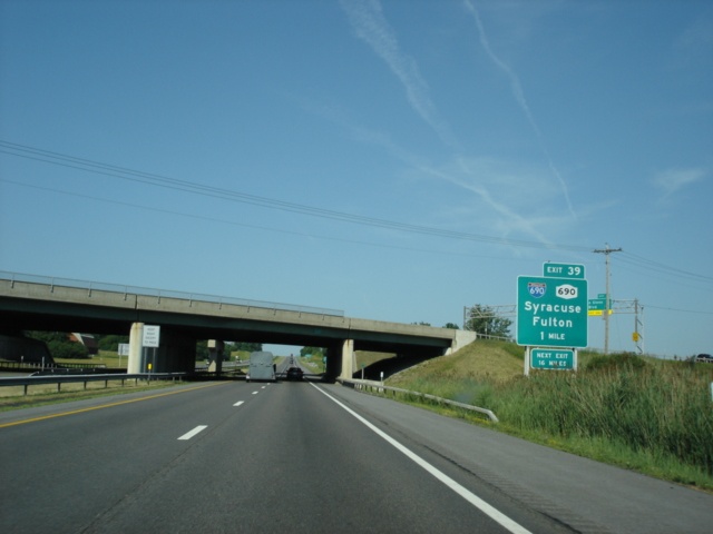 |
Interstate 90 West approaching Exit 39 - Interstate 690/New York 690 - 1 mile. Interstate 690 crosses the Thruway at this point, and parallels the Thruway for the next mile leading up to the interchange. The sign bridge seen on Interstate 690 is at Exit 4 for John Glenn Boulevard. (Photo taken 7/10/05) |
 |
Use Interstate 690 east, New York 695 south, New York 5 west, and New York 174 south to Otisco Lake and Skaneateles Lake. (Photo taken 7/10/05) |
 |
Take Interstate 690 East to Exit 7 (New York 297) to the village of Solvay. Use New York 690 North to the village of Baldwinsville. Solvay is home to 6,845 people, and Baldwinsville is home to 7,053 residents. (Photo taken 7/10/05) |
 |
Use Interstate 690 East to Exit 7 to the New York State Fairgrounds. (Photo taken 7/10/05) |
 |
Interstate 90 West at Exit 39 - Interstate 690/New York 690 - Syracuse/Fulton. Exit 40 is 16 miles ahead at New York 34 in Weedsport. (Photo taken 7/10/05) |
 |
Interstate 90 West approaching the Warners service area - 1 1/2 miles. (Photo taken 7/10/05) |
 |
Interstate 90 West approaching the Warners service plaza - 1 mile. The Warners service plaza houses a McDonald's and a Ben & Jerry's ice cream store. (Photo taken 7/10/05) |
 |
Interstate 90 West approaching the Warners service plaza - 1/4 mile. (Photo taken 7/10/05) |
 |
Interstate 90 West at the Warners service plaza. (Photo taken 7/10/05) |
 |
Interstate 90 West approaching Exit 40 - New York 34 - 1 mile. New York 34 begins at the Pennsylvania state line in Waverly and travels north to New York 104 near Hannibal. (Photo taken 7/10/05) |
 |
Head south on New York 34 to Owasco Lake. The lake begins just south of Auburn, which is 10 miles to the south. (Photo taken 7/10/05) |
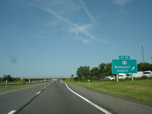 |
Interstate 90 West at Exit 40 - New York 34 - Weedsport/Auburn. The city of Auburn is the seat of Cayuga County and is home to 28,574 residents. (Photo taken 7/10/05) |
 |
Use exits 41 through 44 to the Finger Lakes Wine Country. (Photo taken 7/10/05) |
 |
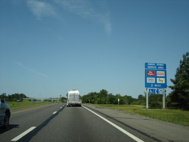
Interstate 90 West approaching the Junius Ponds service area - 14 miles. The Junius Ponds area includes a Roy Rogers and a Dunkin' Donuts. (Photo taken 7/10/05) |
 |
Interstate 90 West travels through the Montezuma National Wildlife Refuge between exits 40 and 41 near the Seneca-Cayuga county line. (Photo taken 7/10/05) |
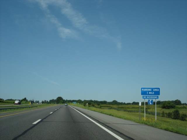 |
Interstate 90 West approaching the Seneca County parking area - 1 mile. (Photo taken 7/10/05) |
 |
The next service area (Junius Ponds) is seven miles ahead. (Photo taken 7/10/05) |
 |
Interstate 90 West at the Seneca County parking area. (Photo taken 7/10/05) |
 |
Interstate 90 West approaching the Junius Ponds service area - 5 miles. (Photo taken 7/10/05) |
 |
Interstate 90 West approaching Exit 41 - New York 414 - 1 mile. New York 414 provides an alternative route to New York 14 and stays east of Seneca Lake, whereas New York 14 stays to the west of the finger lake. (Photo taken 7/10/05) |
 |
Use New York 414 South to Cayuga Lake and the Montezuma National Wildlife Refuge. (Photo taken 7/10/05) |
 |
Seven miles to the south of the Thruway on New York 414 and U.S. 20 is the town of Seneca Falls, which is home to the Women's Rights National Historical Park. The first women's rights convention was held in Seneca Falls in July 1848. (Photo taken 7/10/05) |
 |
Interstate 90 West at Exit 41 - New York 414 - Waterloo/Clyde. Clyde is nine miles to the north at the intersection of New York 31 and New York 414. (Photo taken 7/10/05) |
 |
Interstate 90 West approaching the Junius Ponds service area - 2 miles. (Photo taken 7/10/05) |
 |
The next service area is 28 miles ahead in Ontario County. (Photo taken 7/10/05) |
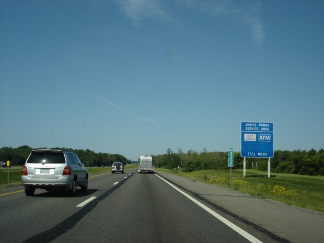 |
Interstate 90 West passes mile marker 322 of the Thruway as the 1 1/2 advance sign for the Junius Ponds service area appears. (Photo taken 7/10/05) |
 |
Interstate 90 West approaching the Junius Ponds service area - 1 mile. (Photo taken 7/10/05) |
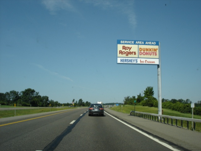 |
Interstate 90 West approaching the Junius Ponds service area - 1/4 mile. The area also includes a Hershey's Ice Cream location. (Photo taken 7/10/05) |
 |
Interstate 90 West at the Junius Ponds service area. (Photo taken 7/10/05) |
 |
Mileage sign on Interstate 90 West just past the Junius Ponds service area. Rochester is 40 miles ahead, and Buffalo is exactly 100 miles away. (Photo taken 7/10/05) |
 |
Interstate 90 West approaching Exit 42 - New York 14 - 1 mile. The state highway travels through Elmira, Horseheads, Watkins Glen, and Geneva along its journey. (Photo taken 7/10/05) |
 |
Use New York 14 South to Seneca Lake. Head north on the state highway for 24 miles to Sodus Bay, which is the northern terminus of New York 14 near Lake Ontario. (Photo taken 7/10/05) |
 |
New York 96 parallels the Thruway on the south from New York 14 westward to the Interstate 490 westbound interchange (Exit 45). Go west on New York 96 to the village of Clifton Springs. (Photo taken 7/10/05) |
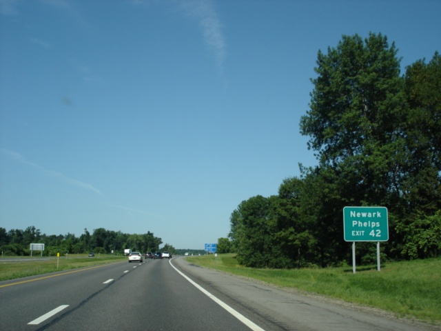 |
Also head west on New York 96 to Phelps. The village of Newark is 14 miles to the northwest via New York 14 north and New York 31 west. (Photo taken 7/10/05) |
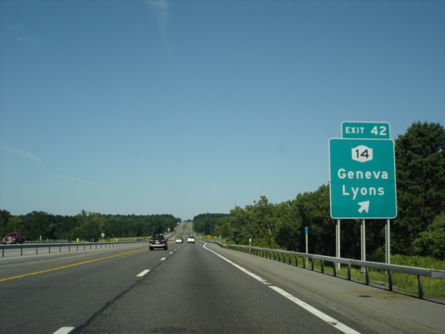 |
Interstate 90 West at Exit 42 - New York 14 - Geneva/Lyons. The westbound Thruway enters Ontario County just before this interchange. (Photo taken 7/10/05) |
 |
Interstate 90 West approaching the Seneca service area - 12 miles. Burger King and Sbarro are the main food choices offered. (Photo taken 7/10/05) |
 |
Interstate 90 West approaching Exit 43 - New York 21 - 1 mile. New York 21 extends much of the vertical length of the western half of New York from New York 417 in Andover to New York 104 in Williamson. (Photo taken 7/10/05) |
 |
Head south on New York 21 for three miles to the village of Shortsville and eight miles to the city of Canandaigua. Canandaigua is the seat of Ontario County and has a population of 11,264. (Photo taken 7/10/05) |
 |
Canandaigua is located at the northern tip of a finger lake named after the city. (Photo taken 7/10/05) |
 |
Interstate 90 West at Exit 43 - New York 21 - Manchester/Palmyra. The town and village of Palmyra is six miles to the north at New York 31. (Photo taken 7/10/05) |
 |
Interstate 90 West approaching the Seneca service area - 8 miles. (Photo taken 7/10/05) |
 |
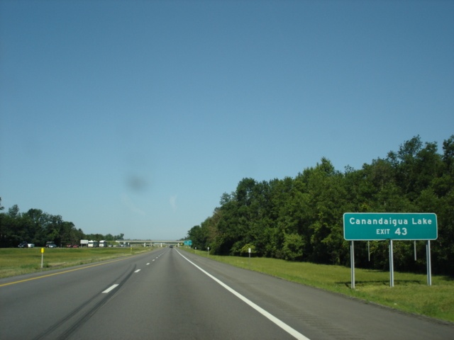
Interstate 90 West approaching Exit 44 - New York 332 - 1 mile. New York 332 provides the most direct route between Interstate 90 and Canandaigua and spans 9.5 miles total. A bridge replacement project was in place in this view. (Photo taken 7/10/05) |
 |
The town of Farmington is at the intersection of New York 96 and New York 332. New York 332 can also be used to Canandaigua Lake. (Photo taken 7/10/05) |
 |
Interstate 90 West at Exit 44 - New York 332 - Canandaigua/Victor. Victor is located on New York 96 three miles west of the New York 332 intersection. (Photo taken 7/10/05) |
 |
The Thruway was recently widened to six lanes (three in each direction) between New York 332 and Interstate 490 westbound. Pictured here is the two-mile advance signage for the Seneca service area. (Photo taken 7/10/05) |
 |
The next service area is 28 miles ahead near the western terminus of Interstate 490. (Photo taken 7/10/05) |
 |
Interstate 90 West approaching the Seneca service area - 1 mile. (Photo taken 7/10/05) |
 |
Interstate 90 West approaching the Seneca service area - 3/4 mile. (Photo taken 7/10/05) |
 |
Interstate 90 West passes mile marker 349 just before the Seneca service area. (Photo taken 7/10/05) |
 |
Interstate 90 West at the Seneca service area. Minor roadwork on the shoulder remained before full completion of the widening project. (Photo taken 7/10/05) |
 |
Interstate 90 West approaching Exit 45 - Interstate 490 West - 3/4 mile. Interstate 490 provides the main route between the Thruway and the city of Rochester, New York's 3rd largest city with a population of 219,773. Interstate 490 spans 37.4 miles through the city and has connections to Interstate 390 and Interstate 590 along the way. (Photo taken 7/10/05) |
 |
Interstate 90 West approaching Exit 45 - Interstate 490 West - 1/2 mile. The first westbound interchange of Interstate 490 is just one-half mile north of the Thruway at New York 96, which is signed as Exit 29. (Photo taken 7/10/05) |
 |
Use Interstate 490 West to Exit 29 (New York 96) to Fairport. The Rochester suburb is located off of New York 250. Honeoye Lake is 25 miles to the south via New York 96 eastbound, New York 444 southbound, New York 64 southbound, and westbound U.S. 20A. (Photo taken 7/10/05) |
 |
Interstate 90 West at Exit 45 - Interstate 490 West - Rochester. Downtown Rochester is 15 miles to the northwest. (Photo taken 7/10/05) |
Page created: January 25, 2006
Last updated:
January 26, 2006