TURNPIKE
![]()
TURNPIKE
All northbound
pictures taken March 19, 2003.
All southbound pictures taken March 19, 2003, or August 4, 2003.
Northbound:
 |
DE 1 North assurance shield just north of Exit 95. |
 |
DE 1 North approaching the Dover toll plaza - 1 mile. |
 |
DE 1 North approaching the Dover toll plaza - 1/2 mile. |
 |
DE 1 North
approaching the Dover toll plaza - 1000 feet. |
 |
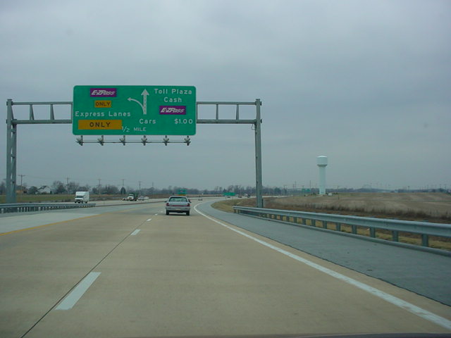
Dover toll plaza
from DE 1 North. A $1 toll is paid at one of these gates, unless you have EZ-Pass. In that case, you would go through one of the three left lanes. |
 |
DE 1 North
approaching Exit 104 - U.S. 13/TO DE 8 - Dover/W. Dover Industrial Area - 1 mile. |
 |
DE 1 North approaching Exit 104 - 1/2 mile. |
 |
DE 1 North at Exit
104 - U.S. 13/TO DE 8 - Dover/W. Dover Industrial Area. |
 |
DE 1 North
approaching Exit 114 - U.S. 13/DE 6/300 - S. Smyrna - 1 mile. |
 |
DE 1 North
approaching Exit 114 - 1/2 mile. Notice that this sign has "TO" on top of the DE 6 and DE 300 shields, unlike the one mile approach signage. |
 |
DE 1 North at Exit
114 - U.S. 13/TO DE 6/300 - S. Smyrna. |
 |
DE 1 North
approaching Exit 119 - U.S. 13 South - N. Smyrna - 1 mile. |
 |
DE 1 North
approaching the end of the expressway - 1 mile. The section between Smyrna and Odessa was open to traffic about two months after I was in the area. |
 |
DE 1 North approaching Exit 119 - 1/2 mile. |
 |
DE 1 North
approaching the end of the expressway - 1/2 mile. There was no BGS for the exit. |
 |
U.S. 13/DE 1 North
approaching Exit 133 - U.S. 13 North - 1 mile. This gantry is no longer necessary with the completion of the turnpike, which eliminated the duplex with U.S. 13. |
 |
U.S. 13/DE 1 North approaching their split. |
 |
U.S. 13 and DE 1
North split here just south of Odessa. |
 |
DE 1 North
approaching Exit 136 - DE 299/TO U.S. 13 - Odessa/Middletown - 1 mile. |
 |
DE 1 North approaching Exit 136 - 1/2 mile. |
 |
DE 1 North at Exit
136 - DE 299/TO U.S. 13 - Odessa/Middletown. |
 |
DE 1 North
approaching Exit 142 - U.S. 13/DE 896/ TO U.S. 301 - Mt. Pleasant/St. Georges - 2 miles. |
 |
DE 1 North approaching Exit 142 - 1/2 mile. |
 |
The Biddles Corner
toll plaza is just north of this exit. This sign gives motorists a choice on how they want to spend a little bit of their money on toll. |
 |
DE 1 North at Exit
142 - U.S. 13/DE 896/TO U.S. 301 - Mt. Pleasant/St. Georges. |
 |
DE 1 North
approaching the Biddles Corner toll plaza - 1 mile. |
 |
DE 1 North
approaching the Biddles Corner toll plaza - 1/2 mile. |
 |
DE 1 North at the
Biddles Corner toll plaza. Another $1 toll is charged here. |
 |
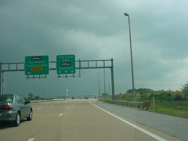
A closer view of
the Biddles Corner toll plaza. The EZ-Pass lanes are to the left of the toll gates, unlike the Dover toll plaza. |
 |
DE 1 North as it
prepares to cross the Chesapeake & Delaware Canal. The old U.S. 13 bridge is more visible from this angle; I was just trying to get the sign! |
 |
The yellow really
stands out on this bridge, which can hold up to six lanes of traffic. |
 |
The toll road ends
with no fanfare at the canal bridge. The freeway continues, however, and this is DE 1 North approaching Exit 152 - DE 72/TO DE 7 - Delaware City/Newark - 1 mile. |
 |
DE 1 North approaching Exit 152 - 1/2 mile. |
 |
DE 1 North at Exit
152 - DE 72/TO DE 7 - Delaware City/Newark. |
 |
DE 1 North
approaching Interstate 95. This sign is located about two miles south of Exit 156 for U.S. 13. U.S. 13 is recommended, however, for those wanting to get to Interstate 295 and the Delaware Memorial Bridge. |
 |
DE 1 North
approaching Exit 156 - U.S. 13 North/TO Interstate 295 - 1 mile. |
 |
DE 1 North approaching Exit 156 - 1/2 mile. |
 |
DE 1 North at Exit
156 - U.S. 13 North/TO Interstate 295 - New Castle/NJ-NY. |
 |
DE 1 North
approaching Exit 160 - U.S. 40 - Elkton Md./State Road - 1 mile. |
 |
DE 1 North approaching Exit 160 - 1/2 mile. |
 |
DE 1 North at Exit
160 - U.S. 40 - Elkton Md./State Road. |
 |
DE 1 North
approaching Exit 162 - DE 273 - Newark/ New Castle - 1/2 mile. |
 |
DE 1 North at Exit
162 - DE 273 - Newark/New Castle. |
 |
DE 1 North
approaching Exit 164 - DE 7 South - Christiana/Mall Road - 1/2 mile. |
 |
DE 1 North approaching Exit 164 - 1/4 mile. |
 |
DE 1 North at Exit
164 - DE 7 South - Christiana/Mall Road. |
 |
DE 1 North
approaching Exits 165A-B - Interstate 95/ TO Interstate 295/495 - Wilmington/Baltimore - 1/2 mile. |
 |
DE 1/7 North
approaching Exit 165B - Interstate 95 North - Wilmington - Next Right. |
 |
DE 1/7 North at
Exit 165B - Interstate 95 North/TO Interstate 295/495 - Wilmington/Philadelphia. |
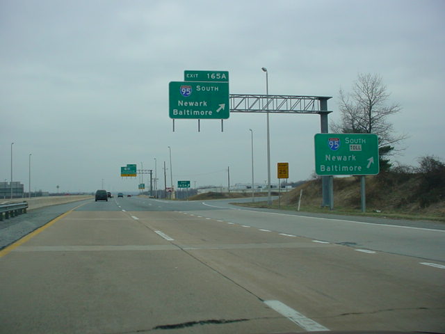 |
DE 1/7 North at
Exit 165A - Interstate 95 South - Newark/Baltimore. There is a $2 toll for driving the seven miles between here and the Maryland State Line. |
 |
DE 1/7 North at
Exit 166 - DE 58 - Churchmans Rd./ Churchmans Crossing. The little green sign in the median just ahead is the "DE 1 END" sign. The freeway ends here, and DE 7 becomes a surface street. |
Southbound:
 |
DE 1/7 South at
Exit 165B - Interstate 95 North - Wilmington/Philadelphia. |
  |
DE 1/7 South
approaching Exits 164A-B - DE 7 South/ Mall Road. This is one of the biggest signs I have ever seen. The sign, however,
has been replaced, as I noticed in |
  |
DE 1/7 South at Exit 164A - Mall Road. |
  |
DE 1/7 South at Exit 164B - DE 7 South - Christiana. |
  |
DE 1 South at Exit
162 - DE 273 - Newark/New Castle. |
  |
DE 1 South at Exit
160 - U.S. 40 - Elkton Md./State Road. |
 |
DE 1 South
approaching Exit 156 - U.S. 13 North/DE 71 South - Wilmington/Red Lion - 1/2 mile. |
 |
DE 1 South approaching Exit 156 - 1/4 mile. |
  |
DE 1 South at Exit
156 - U.S. 13 North/DE 71 South - Wilmington/Red Lion. |
  |
U.S. 13/DE 1 South
at Exit 152 - U.S. 13 South/DE 72 - Delaware City/St. Georges. |
 |
DE 1 South
approaching Exit 148 - TO U.S. 13 - S. St. Georges - 1 mile. The Chesapeake & Delaware Canal bridge is just ahead. |
 |
DE 1 South approaching toll plaza - 2 miles. |
 |
DE 1 South as it
prepares to cross the Chesapeake & Delaware Canal bridge. |
  |
DE 1 South at Exit
148 - TO U.S. 13 - S. St. Georges. This is the final exit before the toll road begins. |
 |
DE 1 South approaching toll plaza - 3/4 mile. |
  |
DE 1 South approaching toll plaza - 1/4 mile. |
 |
DE 1 South at the Biddles Corner toll plaza. |
  |
DE 1 South at Exit
142 - U.S. 13/DE 896/TO U.S. 301 - Mt. Pleasant/Boyds Corner. |
  |
DE 1 South at Exit
136 - DE 299/TO U.S. 13 - Odessa/Middletown. |
 |
DE 1 South
approaching the end of the northern section of the turnpike - 1/2 mile. With the completion of the turnpike between Smyrna and Odessa since I was in the area, this sign is no longer standing. |
 |
A look at what was
the future DE 1, from about Exit 133. |
 |
U.S. 13/Former DE 1
South approaching Exit 119B - U.S. 13 South/TO DE 6/300 - 2 miles. |
 |
U.S. 13/Former DE 1
South approaching Exit 119B - 1 1/2 miles. |
 |
DE 1 South
approaching Exit 119A - U.S. 13 South/ TO DE 6/TO DE 300 - Smyrna/Rest Area - 1 mile. This sign is on the newest section of the turnpike. |
 |
DE 1 South approaching Exit 119A - 1/2 mile. |
 |
U.S. 13/DE 1 South approaching Exit 119B - 1/4 mile. |
 |
DE 1 South at Exit
119A - U.S. 13 South/TO DE 6/ TO DE 300 - Smyrna. |
  |
DE 1 South at Exit 119B - U.S. 13. |
  |
DE 1 South at Exit 114 - U.S. 13 - S. Smyrna. |
 |
DE 1 South
approaching Exit 104 - U.S. 13/TO DE 8/ Dover Downs - N. Dover/W. Dover Industrial Area - 1 mile. |
 |
DE 1 South approaching Exit 104 - 1/2 mile. |
 |
"TO U.S. 13 -
Salisbury/Norfolk - Use Exit 97" sign, located about 1/4 mile north of Exit 104 on DE 1 South. Because if you exit here and want to do that, you would have to go through Dover. Exit 97 is for the Puncheon Run Connector, which connects DE 1 to U.S. 13 south of Dover. |
  |
DE 1 South at Exit
104 - U.S. 13/TO DE 8/Dover Downs - N. Dover/W. Dover Industrial Area. |
 |
DE 1 South at the Dover Toll Plaza. |
 |
DE 1 South
approaching Exit 98 - DE 8 - Downtown Dover/Little Creek - 1 mile. |
 |
DE 1 South approaching Exit 98 - 1/2 mile. |
  |
DE 1 South at Exit
98 - DE 8 - Downtown Dover/Little Creek. |
 |
DE 1 South
approaching Exit 97 - TO U.S. 13 - Salisbury/Norfolk - 1 mile. |
 |
DE 1 South approaching Exit 97 - 1/2 mile. |
  |
DE 1 South at Exit
97 - TO U.S. 13 - Salisbury/ Norfolk. |
Puncheon Run Connector:
 |
West Puncheon Run
Connector approaching U.S. 13 - 1 mile. |
 |
"Expressway
Ends Signal Ahead 3/4 mile" sign on westbound. |
 |
Approaching U.S. 13 - 1/2 mile on westbound. |
 |
West Puncheon Run
Connector at U.S. 13 North - Dover. |
 |
A view from the end of the connector at U.S. 13. |
OKRoads.com Home --> Delaware Highway Guides --> Delaware State Highway Terminus Gallery & Guides
(C) 2003 OKRoads.com. All rights reserved. All pictures on this website were taken by Eric Stuve unless otherwise stated. My pictures may be used on another website under three conditions: 1) E-mail me with your name and URL at webmaster@okroads.com BEFORE putting the picture on your site; 2) You give credit where credit is due (in other words, give credit to the photographer); and 3) You provide a link to OKRoads.com at least one place on your website. If an image is someone else's, please e-mail them and ask them first! I will provide e-mail addresses for other photographers on the page(s) with their images on them.
Last updated November 07, 2003 08:36 PM