 |
Home Search OKRoads: |
|
|
Home Search OKRoads: |
Interstate 40 Tennessee
Eastbound - Interstate 75
South to North Carolina State Line
|
Highway Information |
|
| Miles | 455.28 |
| Counties Traveled Through |
Shelby, Fayette, Haywood, Madison, Henderson, Carroll, Decatur, Benton, Humphreys, Hickman, Dickson, Williamson, Cheatham, Davidson, Wilson, Smith, Putnam, Cumberland, Roane, Loudon, Knox, Sevier, Jefferson, Cocke |
| Cities |
Memphis, Jackson, Nashville, Lebanon, Cookeville, Crossville, Knoxville, Newport |
| Major Junctions |
Interstate 240 (Exit 1E & Exit 12C) Interstate 440 Interstate 65 Interstate 24 Tennessee 840 Interstate 75 Interstate 140 Interstate 640 Interstate 275 Interstate 81 |
| OKRoads Coverage | |
| Miles Driven by OKRoads (Percentage) |
455 (100%) |
| Western End of Interstate Driven |
Arkansas State Line |
| Eastern End of Interstate Driven |
North Carolina State Line |
Pictures
Eastbound:
Lebanon to Interstate 75 South
Interstate 75 South to North Carolina State Line
Westbound:
Jackson to Arkansas State Line
| Interstate 40 East and Interstate 75 North | |
 |
The first exit of the Interstate 40 East/Interstate 75 North duplex is Exit 369, Watt Road, 3/4 mile. Watt Road connects Kingston Pike (U.S. 11 & 70) to Interstate 40. (Photo taken 7/6/05) |
 |
Interstate 40 East and Interstate 75 North at Exit 369 - Watt Road. The next four exits serve the town of Farragut (population 17,720). (Photo taken 7/6/05) |
 |
Interstate 40 and Interstate 75 through Farragut is known as the Troy A. McDill Memorial Highway. (Photo taken 7/6/05) |
 |
Interstate 40 East and Interstate 75 North reassurance shields just east of Watt Road. The duplex is six lanes wide between Interstate 75 South and Exit 374 (Tennessee Secondary 131). (Photo taken 7/6/05) |
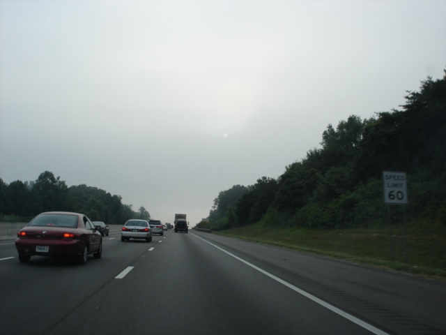 |
The speed limit on the Interstate 40/Interstate 75 duplex is 60 miles per hour. (Photo taken 7/6/05) |
 |
Interstate 40 East and Interstate 75 North approaching Exit 373 - Campbell Station Road - 3/4 mile. (Photo taken 7/6/05) |
 |
Interstate 40 East and Interstate 75 North at Exit 373 - Campbell Station Road. (Photo taken 7/6/05) |
 |
Interstate 40 East and Interstate 75 North approaching Exit 374 - Tennessee Secondary 131/Lovell Road - 1 mile. The route begins at U.S. 11/U.S. 70 just to the south and travels northeast to Tennessee 31 in Treadway. (Photo taken 7/6/05) |
 |
Interstate 40 East and Interstate 75 North at Exit 374 - Tennessee Secondary 131/Lovell Road. (Photo taken 7/6/05) |
 |
The next interchange is the western terminus of Interstate 140, a spur route from Interstate 40 to U.S. 129 in Alcoa. An eastward extension of the interstate was nearing completion in July 2005 that will take the interstate to Tennessee Secondary 33. Exit 376A serves Tennessee 162 North, which continues the route of Interstate 140 into Oak Ridge. Use Tennessee 162 West to Hardin Valley Road to Pellissippi State Technical Community College The American Museum of Science and Energy is located in Oak Ridge. (Photo taken 7/6/05) |
 |
Interstate 40 East and Interstate 75 North approaching Exit 376 - Interstate 140 East/Tennessee 162 North - 3/4 mile. The interchange marks a terminus for both routes. (Photo taken 7/6/05) |
 |
Use Exit 376B (Interstate 140 East) to the McGhee Tyson Airport and Alcoa. (Photo taken 7/6/05) |
 |
Interstate 40 East and Interstate 75 North at Exit 376 - Interstate 140 East and Tennessee 162 North - Oak Ridge/Maryville. Oak Ridge is 13 miles away via Tennessee 162 North and Tennessee 62 West. (Photo taken 7/6/05) |
 |
A collector/distributor system is in place at the Interstate 40/Interstate 75 and Interstate 140/Tennessee 162 interchange. Pictured here is the Exit 376B ramp to Interstate 140 East. The suffixes are switched from the usual order, as in normal circumstances, the first exit heading eastbound would be Exit 376A. (Photo taken 7/6/05) |
 |
Interstate 40 East and Interstate 75 North approaching Exit 378 - Cedar Bluff Road - 1/2 mile. |
 |
Interstate 40 East and Interstate 75 North at Exit 378 - Cedar Bluff Road. The north-south arterial connects Kingston Pike to Middlebrook Pike. (Photo taken 7/6/05) |
 |
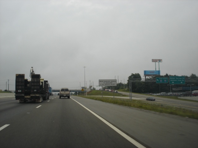
Interstate 40 East and Interstate 75 North approaching Exit 379 - Bridgewater Road/Walker Springs Road/Gallaher View Road - 3/4 mile. All three roads are short and run north-south through the area serving businesses near the interstates and residential areas to the north. (Photo taken 7/6/05) |
 |
Interstate 40 East and Interstate 75 North approaching Exit 379 - Bridgewater Road/Walker Springs Road/Gallaher View Road - 1/2 mile. The right lane becomes the exit only lane. (Photo taken 7/6/05) |
 |
Interstate 40 East and Interstate 75 North at Exit 379 - Bridgewater Road/Walker Springs Road/Gallaher View Road. The first intersection is at Bridgewater Road. (Photo taken 7/6/05) |
 |
Motorists coming from Bridgewater Road are given a ramp to the interstates before the frontage road continues to intersect Walker Springs Road (the next stoplight) and Gallaher View Road. (Photo taken 7/6/05) |
 |
Attached to the Gallaher View Road overpass is the one-mile advance signage for Exit 380, serving U.S. 11 and U.S. 70 (Kingston Pike). The off-ramp ahead stops in front of the West Town Mall. (Photo taken 7/6/05) |
 |
Construction was in progress to widen the freeway between Exit 380 and Exit 383. Here, a temporary sign points the way to Exit 380. (Photo taken 7/6/05) |
 |
Gore point signage at Exit 380. Traffic was shunted to the left while construction was ongoing. (Photo taken 7/6/05) |
 |
Interstate 40 East and Interstate 75 North at Exit 383 - Papermill Road. The arterial parallels the interstates until the Interstate 640 interchange. Tennessee Secondary 332 also plays a part in the interchange, as it begins at the end of this off-ramp. (Photo taken 7/6/05) |
 |
Interstate 40 East and Interstate 75 North approaching Exit 385 - Interstate 75 North/Interstate 640 East - 1 1/4 miles. The control city for Interstate 40 East is still Knoxville even though we have already entered the city. (Photo taken 7/6/05) |
 |
Interstate 40 East and Interstate 75 North approaching Exit 385 - Interstate 75 North/Interstate 640 East - 3/4 mile. The city of Lexington, Kentucky, is 168 miles to the north on Interstate 75. (Photo taken 7/6/05) |
 |
Hazmat vehicles are prohibited from using Interstate 40 through downtown Knoxville, so they are required to use Interstate 640 to bypass the city. Interstate 640 is also being put to good use currently because of the Interstate 40 reconstruction project near downtown Knoxville. The project, known as SmartFix40, began the day that I took these pictures. (Photo taken 7/6/05) |
 |
Interstate 40 East and Interstate 75 North approaching Exit 385 - Interstate 75 North/Interstate 640 East - 1/4 mile. Due to the SmartFix 40 project, Interstate 640 will be used for all Interstate 40 through traffic for 14 months during 2008 and 2009 while Interstate 40 is closed near downtown Knoxville. (Photo taken 7/6/05) |
 |
Interstate 40 East and Interstate 75 North at Exit 385 - Interstate 75 North and Interstate 640 East - Lexington. After a 17-mile duplex, Interstate 40 and Interstate 75 split as Interstate 640 begins. (Photo taken 7/6/05) |
| Interstate 40 East | |
 |
Interstate 40 East approaching Exit 386A - University Avenue/Middlebrook Pike - 1/2 mile, and Exit 386B - U.S. 129 South/Alcoa Highway - 3/4 mile. The overpass seen here carries Liberty Street over the interstate. (Photo taken 7/6/05) |
 |
Knoxville is known as being the home of the University of Tennessee. Use either Exit 386B, Exit 387, or Exit 388 to the campus. (Photo taken 7/6/05) |
 |
Interstate 40 East approaching Exit 386A - University Avenue/Middlebrook Pike - 1/4 mile, and Exit 386B - U.S. 129 South/Alcoa Highway - 1/2 mile. (Photo taken 7/6/05) |
 |
Use Exit 387 to Knoxville College, a lesser-known university in the city of 173,890. (Photo taken 7/6/05) |
 |
Interstate 40 East at Exit 386A - University Avenue/Middlebrook Pike. This is the first of several exits in the next four miles. (Photo taken 7/6/05) |
 |
Interstate 40 East at Exit 386B - U.S. 129/Alcoa Highway - Airport/Smoky Mountains. The McGhee Tyson Airport is located on U.S. 129 12 miles south of downtown Knoxville. U.S. 129 begins here and is a freeway to the Tennessee River. (Photo taken 7/6/05) |
 |
The next interchange is Exit 387, Tennessee Secondary 62/Western Avenue and 17th Street. Use 17th Street south to the East Tennessee Children's Hospital. (Photo taken 7/6/05) |
 |
Interstate 40 East at Exit 387 - Tennessee Secondary 62/Western Avenue/17th Street. The eastern terminus of Tennessee Secondary 62 is less than one-half mile to the southeast at U.S. 441. Interstate 275 is 1/2 mile ahead. (Photo taken 7/6/05) |
 |
Interstate 40 East approaching Exit 387A - Interstate 275 North - 1/4 mile. Interstate 275 is the original Interstate 75 route through downtown Knoxville. After driving Interstate 275 in both directions, I can see why Interstate 75 was rerouted along Interstate 640 in west Knoxville! (Photo taken 7/6/05) |
 |
Interstate 40 East at Exit 387A - Interstate 275 North - Lexington. There are five eastbound lanes prior to this interchange; within the next one-half mile, these will narrow to just two. The SmartFix40 project will take care of this bottleneck. (Photo taken 7/6/05) |
 |
To the Knoxville Convention Center, follow U.S. 441, and to the East Tennessee History Center and Museum of Art, use Tennessee Secondary 62. Both are accessible from Exit 388, which ties into the Interstate 40/275 interchange. (Photo taken 7/6/05) |
 |
A view of the Exit 387A off-ramp connecting Interstate 40 East to Interstate 275 North. To the left, Exit 388 to U.S. 441 and Henley Street southbound departs the freeway. (Photo taken 7/6/05) |
 |
Interstate 40 East at Exit 388A - Tennessee 158/James White Parkway. Tennessee 158 is a freeway to just east of U.S. 441, then becomes a secondary route as it skirts the Tennessee River near the University of Tennessee campus. (Photo taken 7/6/05) |
 |
Interstate 40 East at Exit 389A - U.S. 441 North - Broadway. This narrow, curvy section of interstate will be completely reconstructed in the next several years during the SmartFix40 project. (Photo taken 7/6/05) |
 |
Interstate 40 East approaching Exit 390 - Cherry Street - 1/2 mile. Cherry Street connects Cecil Avenue to the north with U.S. 11/U.S. 70 to the south. East of downtown, the federal highways travel along Magnolia Avenue. (Photo taken 7/6/05) |
 |
Interstate 40 East at Exit 390 - Cherry Street. It is a bit difficult to see the sign due to the semi in the way. (Photo taken 7/6/05) |
 |
Interstate 40 East approaching Exit 393 - Interstate 640 West to Interstate 75 North - 2 miles. The upcoming interchange is the eastern terminus of the Knoxville downtown bypass. (Photo taken 7/6/05) |
 |
Interstate 40 East approaching Exit 392 - U.S. 11W - 1 mile. U.S. 11 splits into two separate routes just to the south of Exit 392. U.S. 11W and U.S. 11E will reunite in Bristol, Virginia. (Photo taken 7/6/05) |
 |
The Knoxville Zoo is located off U.S. 11W south of Interstate 40. (Photo taken 7/6/05) |
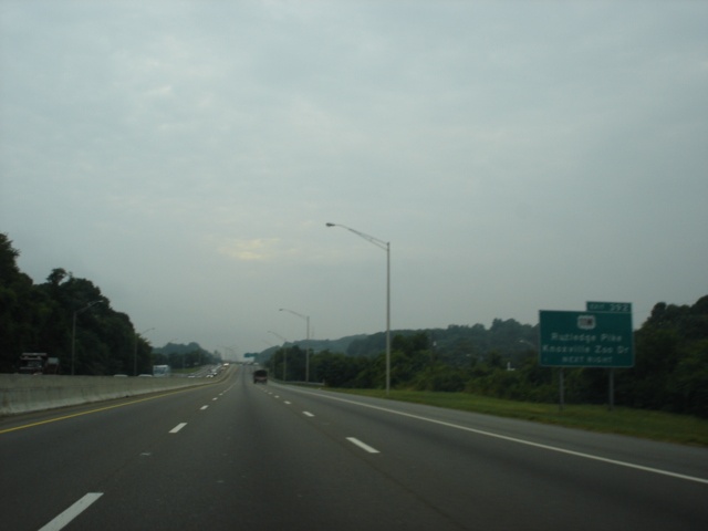 |
Interstate 40 East approaching Exit 392 - U.S. 11W - Next Right. U.S. 11W is also known as Tennessee 1. (Photo taken 7/6/05) |
 |
Interstate 40 East at Exit 392 - U.S. 11W/Rutledge Pike/Knoxville Zoo Drive. Interstate 640 is one-half mile ahead. (Photo taken 7/6/05) |
 |
Interstate 40 East approaching Exit 393 - Interstate 640 West to Interstate 75 North - 1/8 mile. U.S. 25W, which has duplexed with Interstate 640 since Exit 3 (Interstate 75/Interstate 275) will join Interstate 40 for a short duplex. (Photo taken 7/6/05) |
 |
Interstate 40 East at Exit 393 - Interstate 640 West/U.S. 25W North/TO Interstate 75 North - Lexington. The Kentucky city is located where Interstate 64 and Interstate 75 intersect. (Photo taken 7/6/05) |
 |
Interstate 40 East approaching Exit 394 - U.S. 11E/U.S. 25W/U.S. 70 - 1 mile. The bridge over us here is the ramp carrying Interstate 40 East to Interstate 640 West. (Photo taken 7/6/05) |
 |
Interstate 40 East and U.S. 25W South approaching Exit 394 - U.S. 11E/U.S. 25W/U.S. 70 - 1/2 mile. Asheville, North Carolina, is now the control city for Interstate 40. The city is 110 miles away from this point. (Photo taken 7/6/05) |
 |
Interstate 40 East and U.S. 25W South at Exit 394 - U.S. 11E/U.S. 25W South/U.S. 70. The three federal highways will share pavement for the next six miles. (Photo taken 7/6/05) |
 |
Mileage sign on Interstate 40 East near mile marker 395. Sevierville is 20 miles ahead via Tennessee 66 South, while Asheville is 108 miles ahead. Interstate 40 is three lanes in each direction until the Interstate 81 interchange (Exit 421). (Photo taken 7/6/05) |
 |
Interstate 40 East approaching Exit 398 - Strawberry Plains Pike - 1 mile. (Photo taken 7/6/05) |
 |
Region 1 headquarters of the Tennessee Department of Transportation is located near Exit 398. (Photo taken 7/6/05) |
 |
Johnson Bible College is a nondenominational college located off of Tennessee 168 southeast of Knoxville. Take Strawberry Plains Pike southwest, Tennessee 168 south, French Road south, and Kimberlin Heights Road east to the campus. (Photo taken 7/6/05) |
 |
Interstate 40 East at exit 398 - Strawberry Plains Pike. This marks the eastern end of the Knoxville metropolitan area. There is one more exit in Knox County. (Photo taken 7/6/05) |
 |
Interstate 40 East approaching Exit 402 - Midway Road - 1 mile. The diamond interchange is about midway between downtown Knoxville and Interstate 81. (Photo taken 7/6/05) |
 |
Interstate 40 East at Exit 402 - Midway Road. (Photo taken 7/6/05) |
 |
The next interchange serves Tennessee 66, a major north-south state highway connecting Interstate 40 to Sevierville, Pigeon Forge, and Gatlinburg. Use Tennessee 66 South and U.S. 441 south to the Great Smoky Mountains National Park. (Photo taken 7/6/05) |
 |
Also use Tennessee 66 and U.S. 441 south to the Dollywood amusement park, the Ober Gatliburg ski resort, and Ripley's Aquarium of the Smokies. Smokies Park, home of the Tennessee Smokies AA minor league baseball team, is located just north of the interstate. (Photo taken 7/6/05) |
 |
Interstate 40 East approaching Exit 407 - Tennessee 66 - 1 mile. The state highway provides the main route between Interstate 40 and the Great Smoky Mountains tourist areas. (Photo taken 7/6/05) |
 |
A tourist information center is located near Exit 407, providing brochures for the many local attractions. (Photo taken 7/6/05) |
 |
Interstate 40 East at Exit 407 - Tennessee 66. This is the northern terminus of the state highway, which is four-lane divided for its entire length between U.S. 411/U.S. 441 and Interstate 40. Sevierville, where Tennessee 66 ends at U.S. 411 and U.S. 441, is 8 1/2 miles away, Pigeon Forge is 15 miles away, and Gatlinburg is 22 miles away. (Photo taken 7/6/05) |
 |
Mileage sign on Interstate 40 East immediately after Exit 407. Bristol is 91 miles ahead via Interstate 81 North. For those continuing on Interstate 40, Asheville is 94 miles away. Chances are that from here, one will get to Bristol before Asheville, since Interstate 40 winds its way through the Smokies near the North Carolina state line, whereas Interstate 81 provides a straight shot to Bristol, located on the Tennessee-Virginia border. (Photo taken 7/6/05) |
 |
Interstate 40 East approaching Exit 412 - Deep Springs Road/Douglas Dam - 1 mile. Deep Springs Road connects Tennessee Secondary 139 to U.S. 25W/U.S. 70. (Photo taken 7/6/05) |
 |
Interstate 40 East at Exit 412 - Deep Springs Road/Douglas Dam. (Photo taken 7/6/05) |
 |
Interstate 40 East approaching Exit 415 - U.S. 25W/U.S. 70 - 1 mile. U.S. 25W and U.S. 70 stick close to Interstate 40 between Knoxville and Newport. (Photo taken 7/6/05) |
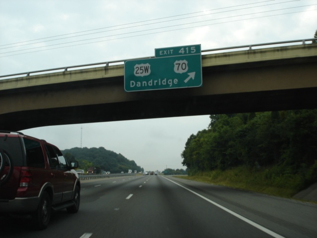 |
Interstate 40 East at Exit 415 - U.S. 25W/U.S. 70. This is the first of three interchanges to serve the city of Dandridge (pop. 2,078). The city is located along the north shore of Douglas Lake at the intersection of U.S. 25W, U.S. 70, and Tennessee 92. Two secondary highways, Tennessee Secondary 66 and Tennessee Secondary 139, also come into play. (Photo taken 7/6/05) |
 |
Interstate 40 East approaching Exit 417 - Tennessee 92 - 1 mile. Jefferson City, located at the intersection of U.S. 11E and Tennessee 92, is seven miles northwest. (Photo taken 7/6/05) |
 |
Interstate 40 East at Exit 417 - Tennessee 92 - Dandridge/Jefferson City. (Photo taken 7/6/05) |
 |
The final Interstate 40 rest area in Tennessee is located near mile marker 419. No oversized loads are allowed into the rest area. (Photo taken 7/6/05) |
 |
Interstate 40 East at the Jefferson County rest area. For those taking Interstate 81 North, there is a rest area in Greene County between Exit 36 and Exit 44. (Photo taken 7/6/05) |
 |
Interstate 40 East approaching Exit 421 - Interstate 81 North - 2 miles. Interstate 81 is a major north-south trucking corridor through Tennessee, Virginia, West Virginia, Maryland, Pennsylvania, and New York. (Photo taken 7/6/05) |
 |
Interstate 40 East approaching Exit 421 - Interstate 81 North - 1 mile. Interstate 81 spends 75 miles in the Volunteer State. (Photo taken 7/6/05) |
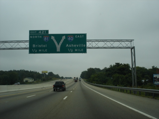 |
Interstate 40 East approaching Exit 421 - Interstate 81 North - 1/2 mile. (Photo taken 7/6/05) |
 |
The sign bridge at the interchange had been taken down at the time of this photograph, so these temporary signs were in place. A similar sign just off to the left tells Interstate 81 traffic to stay to the left. We can see Interstate 81 North as it heads underneath the westbound lanes of Interstate 40. From here to U.S. 23 and U.S. 74 near Waynesville, North Carolina, Interstate 40 runs mostly in a north-south fashion. (Photo taken 7/6/05) |
 |
Interstate 40 East approaching Exit 424 - Tennessee Secondary 113 - 1 mile. This is the third and final exit for the city of Dandridge. Tennessee Secondary 113 begins at U.S. 25W and U.S. 70 just to the west of Interstate 40 and travels northeastward to Tennessee 66 south of Rogersville. (Photo taken 7/6/05) |
 |
Interstate 40 East at Exit 424 - Tennessee Secondary 113 - Dandridge/White Pine. White Pine is five miles to the north. (Photo taken 7/6/05) |
 |
This view of the French Broad River is provided immediately after Exit 424. (Photo taken 7/6/05) |
 |
At mile marker 428, the Great Smoky Mountains begin to come into view. The mountains lived up to their name on this day, as skies were cloudy and foggy. (Photo taken 7/6/05) |
 |
Interstate 40 East approaching Exits 432A-B - U.S. 25W/U.S. 70/U.S. 411 - 1 mile. The interchange marks the northern terminus of U.S. 411 and contains a left exit to U.S. 25W South and U.S. 70 East. (Photo taken 7/6/05) |
 |
Interstate 40 East approaching Exit 432A - U.S. 411 South - Next Right. The ramp also provides return access to U.S. 25W North and U.S. 70 West, although this is not specified on any signs. (Photo taken 7/6/05) |
 |
Interstate 40 East at Exit 432A - U.S. 25W North/U.S. 70 West/U.S. 411 South. Sevierville, named after John Sevier, the first governor of Tennessee, is 20 miles southwest of here. (Photo taken 7/6/05) |
 |
Interstate 40 East approaching Exit 432B - U.S. 25W/U.S. 70 East - Next Left. Newport (pop. 7,242) is where U.S. 25, U.S. 70, and U.S. 321. (Photo taken 7/6/05) |
 |
Interstate 40 East at Exit 432B - U.S. 25W/U.S. 70 East - Newport. The split routes of U.S. 25 unite three miles to the east. (Photo taken 7/6/05) |
 |
Interstate 40 East approaching Exit 435 - U.S. 321/Tennessee 32 - 1 mile. The highways duplex between Cosby and Newport, a distance of 13 miles. (Photo taken 7/6/05) |
 |
Interstate 40 East at Exit 435 - U.S. 321/Tennessee 32 - Newport/Gatliburg. A 31 mile drive separates Newport and Gatlinburg. (Photo taken 7/6/05) |
 |
U.S. 321 and Tennessee 32 southbound is accessed via a right-hand turn. U.S. 321 is signed in an opposite direction here from what it was at the last time where Interstate 40 and U.S. 321 met back at Exit 364. This is the last interchange with multiple tourist services until North Carolina. (Photo taken 7/6/05) |
 |
Mileage sign on Interstate 40 East just past Exit 435. Asheville is 67 miles or 108 kilometers ahead. The drive between Newport and Asheville is very curvy and scenic. (Photo taken 7/6/05) |
 |
Exit 440 serves Wilton Spring Road, a connector between Interstate 40 and U.S. 321/Tennessee 32. The road is signed as Tennessee Secondary 73 and travels northward to U.S. 25 and U.S. 70 in east Newport. (Photo taken 7/6/05) |
 |
Interstate 40 East approaching Exit 440 - Tennessee Secondary 73 - 1 mile. (Photo taken 7/6/05) |
 |
Interstate 40 East at Exit 440 - Tennessee Secondary 73 TO U.S. 321 - Wilton Springs Road/Gatlinburg. It appears the signmakers forgot to put a space between "Springs" and "Rd." on the BGS. (Photo taken 7/6/05) |
 |
A weigh station is located near mile marker 441. (Photo taken 7/6/05) |
 |
Trees and mountains begin to surround the interstate as we approach Exit 443 for the Foothills Parkway. No commercial vehicles are allowed on the scenic road along the foothills of the Great Smoky Mountains. (Photo taken 7/6/05) |
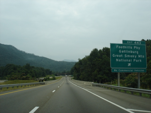 |
Interstate 40 East at Exit 443 - Foothills Parkway/Gatlinburg/Great Smoky Mountains National Park. (Photo taken 7/6/05) |
 |
Tractor trailers must use the right lane through the Great Smoky Mountains. Get used to the concrete median divider, because we will be seeing it for most of the next 30 miles. (Photo taken 7/6/05) |
 |
Interstate 40 East as it enters the Cherokee National Forest. The forest encompasses 640,000 acres and is the largest section of public land in the state. (Photo taken 7/6/05) |
 |
Mileage sign on Interstate 40 East at mile marker 445. Waynesville is 39 miles away, while Asheville is still 59 miles ahead. (Photo taken 7/6/05) |
 |
The next two pictures are somewhat blurry, but they still somewhat portray the scenery in the area. Exit 447 serves Hartford Road and the Martha Sundquist State Forest, located entirely within the Cherokee National Forest. (Photo taken 7/6/05) |
 |
Very blurry picture of the one-mile advance signage for Exit 447 and Hartford Road. (Photo taken 7/6/05) |
 |
If whitewater rafting floats your boat, take Exit 447. (Photo taken 7/6/05) |
 |
Interstate 40 East at Exit 447 - Hartford Road. (Photo taken 7/6/05) |
 |
View from Interstate 40 East at mile marker 448. Fences are in place along the shoulder to protect the freeway from falling rock. Unfortunately, some rockslides prove to be too big for the fences to handle. This is true especially in North Carolina, as large rockslides in recent years have affected travel on Interstate 40. (Photo taken 7/6/05) |
 |
View from Interstate 40 East at mile marker 449. Interstate 40 through the Smokies is one of those stretches of road where its scenery cannot be fully captured in pictures. (Photo taken 7/6/05) |
 |
Interstate 40 East approaching Exit 451 - Waterville Road - 1 mile. The upcoming interchange is the final one in Tennessee after spending the last 450 miles in the state. Then Interstate 40 spends its final 421 miles in North Carolina. (Photo taken 7/6/05) |
 |
View from mile marker 450 of Interstate 40 East. The interstate was built into the Pigeon River Gorge. (Photo taken 7/6/05) |
 |
Interstate 40 East at Exit 451 - Waterville Road. A yellow sign proclaiming a left curve blocks the way of the exit BGS. (Photo taken 7/6/05) |
 |
Gore point signage at Exit 451. The interchange here is a full diamond. (Photo taken 7/6/05) |
 |
The final mileage sign in the state of Tennessee proclaims that we are 32 and 52 miles from Waynesville and Asheville, respectively. (Photo taken 7/6/05) |
 |
Just before entering North Carolina, we leave the Cherokee National Forest. The next green sign (barely visible here) marks the North Carolina state line. (Photo taken 7/6/05) |
Page created: October 30, 2005
Last updated:
October 31, 2005