 |
Home Search OKRoads: |
|
|
Home Search OKRoads: |
Interstate 39 Illinois
Northbound - Interstate 55 to Interstate
80
|
Highway Information |
|
| Miles | 123.42 |
| Counties Traveled Through |
McLean, Woodford, Marshall, La Salle, Lee, Ogle, Winnebago |
| Cities |
La Salle, Mendota, Rockford |
| Major Junctions |
Interstate 55
Interstate 80 Interstate 88 |
| OKRoads Coverage | |
| Miles Driven by OKRoads (Percentage) |
123 (100%) |
| Southern End of Interstate Driven |
Interstate 55 |
| Northern End of Interstate Driven |
Wisconsin State Line |
Pictures
Northbound:
Interstate 55 to Interstate 80
Interstate 80 to Wisconsin State Line
| Interstate 39 and U.S. 51 North | |
 |
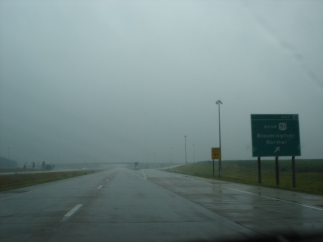
Our trip on Interstate 39 began with a rainstorm due to the remnants of Hurricane Dennis, which made landfall in Florida two days earlier. Don't worry, the rain only lasted for the first eight miles on Interstate 39, then stopped for a while, so only the first 10 or so pictures are rainy. This sign says "Begin Interstate 39 North - Bloomington-Normal To Wisconsin". (Photo taken 7/12/05) |
 |
Interstate 39 and U.S. 51 North approaching Exit 2 - Business U.S. 51 - 1/2 mile. Business U.S. 51 is the original route of U.S. 51 through Bloomington-Normal. (Photo taken 7/12/05) |
 |
Interstate 39 and U.S. 51 North at Exit 2 - Business U.S. 51 - Bloomington-Normal. (Photos taken 7/12/05) |
 |
|
 |
Interstate 39 and U.S. 51 North approaching Exit 5 - Hudson - 1 mile. The village of Hudson is home to 1,510 residents. (Photo taken 7/12/05) |
 |
Interstate 39 and U.S. 51 North approaching Exit 5 - Hudson - 1/2 mile. (Photo taken 7/12/05) |
 |
Interstate 39 and U.S. 51 North at Exit 5 - Hudson. (Photo taken 7/12/05) |
 |
Interstate 39 and U.S. 51 North approaching Exit 8 - Illinois 251 - 1 mile. Illinois 251 is the original route of U.S. 51 before Interstate 39 was built and U.S. 51 was put onto the interstate. Kappa (pop. 170) is two miles to the north. (Photo taken 7/12/05) |
 |
Head west on McLean County 8 to Comlara Park and Evergreen Lake. (Photo taken 7/12/05) |
 |
Interstate 39and U.S. 51 North approaching Exit 8 - Illinois 251 - 1/2 mile. (Photo taken 7/12/05) |
 |
Interstate 39 and U.S. 51 North at Exit 8 - Illinois 251 - Kappa/Lake Bloomington Road. Lake Bloomington is 3.5 miles to the east of the interstate. (Photo taken 7/12/05) |
 |
Interstate 39 and U.S. 51 North approaching Exit 14 - U.S. 24 - 1 mile. El Paso (pop. 2,695) is just to the east, and Peoria (pop. 112,936) is 32 miles to the west. (Photo taken 7/12/05) |
 |
Interstate 39 and U.S. 51 North approaching Exit 14 - U.S. 24 - 1/2 mile. (Photo taken 7/12/05) |
 |
Interstate 39 and U.S. 51 North at Exit 14 - U.S. 24 - El Paso/Peoria. (Photo taken 7/12/05) |
 |
Interstate 39 and U.S. 51 North approaching Exit 22 - Illinois 116 - 1 mile. The state highway spans 190 miles from U.S. 34 near Biggsville to U.S. 45 in Ashkum. (Photo taken 7/12/05) |
 |
Interstate 39 and U.S. 51 North approaching Exit 22 - Illinois 116 - 1/2 mile. (Photo taken 7/12/05) |
 |
Interstate 39 and U.S. 51 North at Exit 22 - Illinois 116 - Peoria/Pontiac. Pontiac is home to 11,864 residents and is located where Illinois 116 meets Interstate 55, 24 miles to the east. (Photo taken 7/12/05) |
 |
Interstate 39 and U.S. 51 North approaching Exit 27 - Minonk - 1 mile. Minonk is located along Illinois 251 between Exits 22 and 27. (Photo taken 7/12/05) |
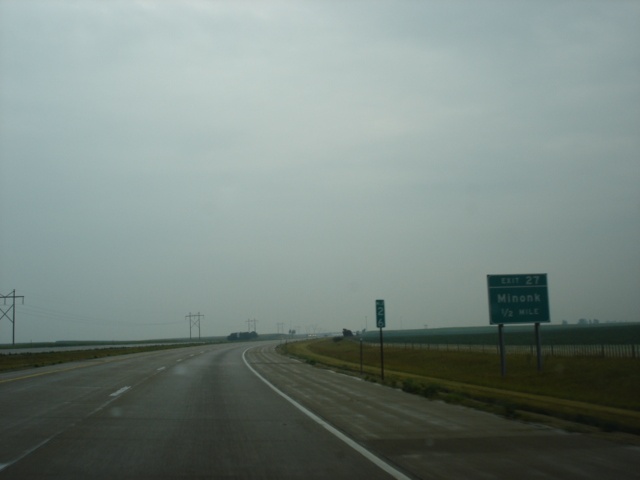 |
Interstate 39 and U.S. 51 North approaching Exit 27 - Minonk - 1/2 mile. (Photo taken 7/12/05) |
 |
Interstate 39 and U.S. 51 North at Exit 27 - Minonk. (Photo taken 7/12/05) |
 |
Interstate 39 and U.S. 51 North approaching Exit 35 - Illinois 17 - 1 mile. Illinois 17 spans the entire horizontal length of the state from the Mississippi River to the Indiana state line. (Photo taken 7/12/05) |
 |
Use Illinois 17 West and Illinois 117 South to the city of Toluca, population 1,339. (Photo taken 7/12/05) |
 |
Interstate 39 and U.S. 51 North approaching Exit 35 - Illinois 17 - 1/2 mile. Lacon is located along the Illinois River 19 miles to the west. (Photo taken 7/12/05) |
 |
Interstate 39 and U.S. 51 North at Exit 35 - Illinois 17 - Lacon/Wenona. (Photo taken 7/12/05) |
 |
Interstate 39 and U.S. 51 North approaching Exit 41 - Illinois 18 - 1 mile. Illinois 18 is 37 miles long from Illinois 29 in Henry to Illinois 17 in Blackstone. (Photo taken 7/12/05) |
 |
Use Illinois 18 East to Illinois 251 North to Lostant. (Photo taken 7/12/05) |
 |
Interstate 39 and U.S. 51 North approaching Exit 41 - Illinois 18 - 1/2 mile. The city of Henry (pop. 2,540) is 16 miles to the west, and the city of Streator (pop. 14,190) is 14 miles to the east. (Photo taken 7/12/05) |
 |
Interstate 39 and U.S. 51 North at Exit 41 - Illinois 18 - Henry/Streator. (Photo taken 7/12/05) |
 |
Mileage sign on Interstate 39 and U.S. 51 North just past Illinois 18. Tonica is the next exit six miles ahead, Interstate 80 is 16 miles ahead, and Rockford is still 87 miles away. (Photo taken 7/12/05) |
 |
Interstate 39 and U.S. 51 North approaching Exit 48 - Tonica - 1 mile. Tonica (pop. 685) is another Illinois 251 village. (Photo taken 7/12/05) |
 |
Interstate 39 and U.S. 51 North approaching Exit 48 - Tonica - 1/2 mile. (Photo taken 7/12/05) |
 |
Interstate 39 and U.S. 51 North at Exit 48 - Tonica. (Photo taken 7/12/05) |
 |
Mileage sign on Interstate 39 and U.S. 51 North just past Exit 48. The next exit is Illinois 71 in two miles. (Photo taken 7/12/05) |
 |
Interstate 39 and U.S. 51 North approaching Exit 51 - Illinois 71 - 1 mile. Illinois 71 travels 70 miles from Interstate 180 in Hennepin to U.S. 34 in Oswego. (Photo taken 7/12/05) |
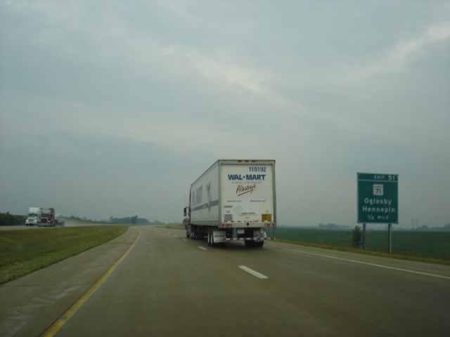 |
Interstate 39 and U.S. 51 North approaching Exit 51 - Illinois 71 - 1/2 mile. Hennepin is 14 miles to the west. (Photo taken 7/12/05) |
 |
Interstate 39 and U.S. 51 North at Exit 51 - Illinois 71 - Hennepin/Oglesby. This is the first of two exits for the city of Oglesby, population 3,647. (Photo taken 7/12/05) |
 |
Interstate 39 and U.S. 51 North approaching Exit 52 - Illinois 251 - 1/2 mile. At the ahead interchange, Illinois 251 moves to the west of the interstate, and does not stay nearly as close to the interstate as it does to the south of Oglesby. (Photo taken 7/12/05) |
 |
Interstate 39 and U.S. 51 North at Exit 52 - Illinois 251 - La Salle/Peru. The city of Peru (pop. 9,835) is located just west of the state highway on U.S. 6, and the city of La Salle (pop. 9,796) is just to the east. Both cities are about five miles to the north. (Photo taken 7/12/05) |
 |
Just past Illinois 251, Interstate 39 and U.S. 51 enter the Illinois & Michigan Canal National Heritage Corridor. The I & M Canal is 97 miles long and connects the Chicago River near Lake Michigan to Peru. (Photo taken 7/12/05) |
 |
Interstate 39 and U.S. 51 North approaching Exit 54 - Oglesby - 1/2 mile. La Salle County 23 connects the interstate at Exit 54 to Oglesby. (Photo taken 7/12/05) |
 |
Head west on La Salle County 23 to the Illinois Valley Community College. Go east to the Starved Rock State Park and the Starved Rock Lodge & Conference Center. (Photo taken 7/12/05) |
 |
Interstate 39 and U.S. 51 North at Exit 54 - La Salle County 23 - Oglesby. (Photo taken 7/12/05) |
 |
Interstate 39 and U.S. 51 North approaching Exit 57 - U.S. 6 - 2 miles. The surrounding terrain changes a bit as we near the Illinois River. (Photo taken 7/12/05) |
 |
Interstate 39 and U.S. 51 North cross the Illinois River on the Abraham Lincoln Memorial Bridge. Northbound traffic was narrowed to one lane due to construction work. (Photos taken 7/12/05) |
 |
|
 |
Interstate 39 and U.S. 51 North approaching Exit 57 - U.S. 6 - 1/4 mile. U.S. 6 stays close to Interstate 80 through much of Illinois. (Photo taken 7/12/05) |
 |
Interstate 39 and U.S. 51 North at Exit 57 - U.S. 6 - Ottawa/La Salle/Peru. Ottawa is 14 miles to the east. (Photo taken 7/12/05) |
 |
Interstate 39 and U.S. 51 North approaching Exits 59A-B - Interstate 80 - 1 3/4 miles. In Illinois, Interstate 80 travels 163.52 miles. (Photo taken 7/12/05) |
 |
Interstate 39 and U.S. 51 North approaching Exit 59A - Interstate 80 East - 1 mile, and Exit 59B - Interstate 80 West - 1 1/2 miles. (Photo taken 7/12/05) |
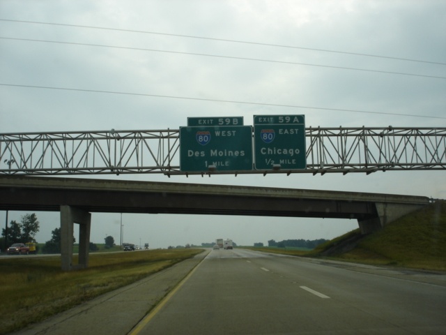 |
Interstate 39 and U.S. 51 North approaching Exit 59A - Interstate 80 East - 1/2 mile, and Exit 59B - Interstate 80 West - 1 mile. Chicago is 95 miles to the east, and Des Moines, Iowa, is 254 miles to the west. (Photo taken 7/12/05) |
 |
Interstate 39 and U.S. 51 North at Exit 59A - Interstate 80 East - Chicago. (Photo taken 7/12/05) |
 |
Interstate 39 and U.S. 51 North at Exit 59B - Interstate 80 West - Des Moines. (Photo taken 7/12/05) |
Page created: February 21, 2006
Last updated:
February 21, 2006