 |
Home Search OKRoads: |
|
|
Home Search OKRoads: |
Interstate 10 Texas
Westbound - Sam Houston Tollway to San
Antonio
|
Highway Information |
|
| Miles | 881.00 |
| Countries Traveled Through |
El Paso, Hudspeth, Culberson, Jeff Davis, Reeves, Pecos, Crockett, Sutton, Kimble, Kerr, Gillespie, Kendall, Bexar, Guadalupe, Gonzales, Fayette, Colorado, Austin, Waller, Fort Bend, Harris, Chambers, Jefferson, Orange |
| Cities | El Paso, Fort Stockton, Kerrville, San Antonio, Houston, Beaumont, Orange |
| Major Junctions | U.S. 54 (Exit 23A) Interstate 20 Interstate 410 Interstate 35 Interstate 35 Interstate 37 Interstate 410 Interstate 610 Interstate 45 U.S. 59 Interstate 610 |
| OKRoads Coverage | |
| Miles Driven by OKRoads (Percentage) |
881 (100%) |
| Western End of Interstate Driven |
New
Mexico State Line |
| Eastern End of Interstate Driven |
Louisiana State Line |
Pictures
Eastbound:
Interstate 410 to Interstate 45
Interstate 45 to Louisiana State Line
Westbound:
Sam Houston Tollway to San Antonio
Fort Stockton to New Mexico State Line
| Westbound | |
 |
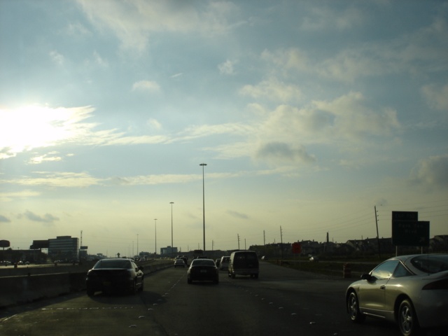
Interstate 10 West approaching Exit 754 - Kirkwood Road - 1 mile. This is how Interstate 10 typically looks in this area, with bumper-to-bumper traffic. Thankfully, construction to widen the freeway is underway. It can't come soon enough. (Photo taken 3/16/05) |
 |
Interstate 10 West at Exit 754 - Kirkwood Road. Just another day on the Katy Freeway. (Photo taken 3/16/05) |
 |
Interstate 10 West at Exit 753B - Dairy-Ashford Road. Dairy-Ashford Road connects to Alternate U.S. 90 12 miles to the south in Sugar Land. From there, Spur 41 connects the road to U.S. 59. (Photo taken 3/16/05) |
 |
Interstate 10 West reaches Exit 753A for Eldridge Parkway, a lengthy surface route connecting Tomball, Satsuma, and Sugar Land. (Photo taken 3/16/05) |
 |
Backlit shot of Interstate 10 West approaching Exit 751 in one-half mile. Exit 751 serves Texas 6, a lengthy north-south route connecting Galveston, Houston, and Waco, before entering the state of Oklahoma near the southwest corner of the Sooner State. (Photo taken 3/16/05) |
 |
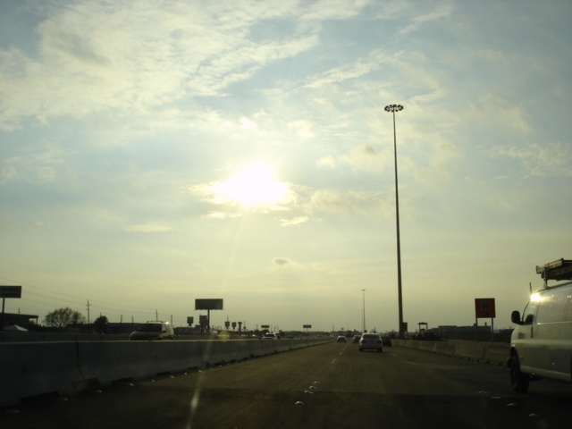
Suddenly, one mile later, the sun came out. It was very unusual to see dark black sky in one picture and nice blue sky in the next less than one mile later, but that is exactly what happened here. No, we did not get off the interstate for a break in between either! Anyway, this is Interstate 10 westbound approaching unsigned Exit 750 for Park Ten Boulevard in one-half mile. The elevated structures carry the high occupancy lanes to park and ride lots. (Photo taken 3/16/05) |
 |
Interstate 10 West at Exit 750 - Park Ten Boulevard. (Photo taken 3/16/05) |
 |
Interstate 10 West approaching Exit 747 - Fry Rd. - 1/2 mile. I apologize for the quality of these photos, but driving into the sun plus smaller signs due to construction equals pictures that are not that great. (Photo taken 3/16/05) |
 |
Interstate 10 West at Exit 747 for Fry Road. (Photo taken 3/16/05) |
 |
Interstate 10 West approaches Exit 746 - Westgreen Boulevard. (Photo taken 3/16/05) |
 |
Interstate 10 West at Exit 746 for Westgreen Boulevard. (Photo taken 3/16/05) |
 |
Interstate 10 West approaches Exit 745 for Mason Road. (Photo taken 3/16/05) |
 |
Interstate 10 West at Exit 745 - Mason Road. (Photo taken 3/16/05) |
 |
Interstate 10 West at Exit 743 for Texas 99 and the Grand Parkway. The Grand Parkway is planned to be Houston's third outer beltway. (Photo taken 3/16/05) |
 |
Interstate 10 West approaching Exit 741, serving U.S. 90 and the suburb of Katy, the namesake for the Katy Freeway, the name for Interstate 10 in west Houston. (Photo taken 3/16/05) |
 |
Interstate 10 West approaching Exit 740 - Farm to Market Road 1463 - Pin Oak Road. The interchange ahead marks the western end of the Katy Freeway and its associated widening project. (Photo taken 3/16/05) |
 |
Interstate 10 West at Exit 740 - Farm to Market Road 1463 - Pin Oak Road. The farm to market road travels through the far western reaches of the Houston metropolitan area. (Photo taken 3/16/05) |
 |
Interstate 10 West approaches Exit 737 for Pederson Road in one mile. (Photo taken 3/16/05) |
 |
Interstate 10 West at Exit 737 - Pederson Road. (Photo taken 3/16/05) |
 |
Interstate 10 West approaching Exit 732 - Farm to Market Road 359 - 1 mile. The left lane ends just ahead, and Interstate 10 West becomes just two lanes wide for the first time since east of Houston. (Photo taken 3/16/05) |
 |
Interstate 10 West reaches Exit 732, serving the city of Brookshire. The city is home to 3,500 residents. (Photo taken 3/16/05) |
 |
Interstate 10 West approaching Exit 731 - Farm to Market Road 1489 - 1/4 mile. (Photo taken 3/16/05) |
 |
Interstate 10 West at Exit 731 - Farm to Market Road 1489 - Koomey Road/Simonton. An eight mile drive separates Interstate 10 from Simonton, located at the intersection of Farm to Market roads 1489 and 1093. (Photo taken 3/16/05) |
 |
Interstate 10 West at the picnic area located at mile marker 730. Peach Ridge Road is three-quarters of a mile ahead via Exit 730. It marks the final interchange in Brookshire. (Photo taken 3/16/05) |
 |
Interstate 10 West approaching Exit 730 - Peach Ridge Road - 1/4 mile. (Photo taken 3/16/05) |
 |
Interstate 10 West at Exit 730 - Peach Ridge Road. U.S. 90 East is also accessible at this exit. Interstate 10 and U.S. 90 become duplexed from this exit westward to Exit 721. (Photo taken 3/16/05) |
 |
Interstate 10 West approaching Exit 725 - Micak Rd. - 1/2 mile. The interstate crosses over the Brazos River ahead. (Photo taken 3/16/05) |
 |
Interstate 10 West at Exit 725 - Micak Rd. (Photo taken 3/16/05) |
 |
Mileage sign on Interstate 10 West near mile marker 724. Sealy is just three miles ahead, while San Antonio is 155 miles ahead. (Photo taken 3/16/05) |
 |
Interstate 10 West approaching Exit 723 - Farm to Market Road 1458 - 1/2 mile. San Felipe is known as the birthplace of Anglo-American settlement in Texas. (Photo taken 3/16/05) |
 |
Interstate 10 West at Exit 723 - Farm to Market Road 1458 - San Felipe/Frydek. Farm to Marker 1458 zigzags through eastern Austin and western Waller counties. (Photo taken 3/16/05) |
 |
Interstate 10 West approaching Exit 721 - U.S. 90 - 1 mile. U.S. 90 leaves the interstate to travel through Sealy before merging back with the interstate at Exit 718. (Photo taken 3/16/05) |
 |
Interstate 10 West approaching U.S. 90 West, one-quarter mile. (Photo taken 3/16/05) |
 |
Interstate 10 West at Exit 721 - U.S. 90 West. (Photo taken 3/16/05) |
 |
Interstate 10 West approaching Exit 720 - Texas 36 - 1 mile. (Photo taken 3/16/05) |
 |
Partially cut-off from the picture (and also a blurry picture to boot), another advance sign for the folded diamond interchange with Texas 36. (Photo taken 3/16/05) |
 |
Interstate 10 West at Exit 720 - Texas 36 - Sealy/Bellville. The city of Bellville, also the seat of Austin County, is home to about 3,800 Texans and is a 14-mile drive away via Texas 36 North. (Photo taken 3/16/05) |
 |
Turning left at this point will take motorists towards downtown Sealy and Bellville. Turning right will take motorists to Wallis in 11 miles and to Rosenberg in 27 miles. (Photo taken 3/16/05) |
 |
Resuming our journey along Interstate 10 West the next morning, we see Exit 716 for Pyka Road. Pyka Road connects Interstate 10 to Farm to Market Road 2187 three miles to the north. (Photo taken 3/17/05) |
 |
Interstate 10 West at Exit 713 - Beckendorff Road. (Photo taken 3/17/05) |
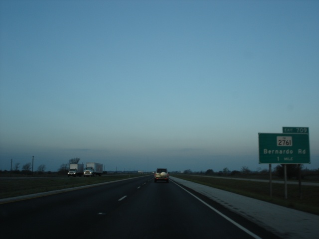 |
The next exit is for Farm to Market Road 2761 and Bernardo Road, one mile ahead. Farm to Market Road 2761 is a six-mile connector route between Farm to Market Road 949 and Interstate 10. (Photo taken 3/17/05) |
 |
Interstate 10 West reaches Exit 709 for Farm to Market Road 2761. Bernardo Road continues the northwest track that the farm to market road departs. (Photo taken 3/17/05) |
 |
The next exit is signed as Exit 704, serving Farm to Market Road 949. The highway begins at Farm to Market Road 1094 near Cat Spring and meets its other end at Farm to Market Road 102 near Ramsey five and a half miles to the south. (Photo taken 3/17/05) |
 |
Interstate 10 West enters the city of Columbus, population 3,916, as the departure of U.S. 90 approaches in one-half mile. U.S. 90 breaks away from the interstate in Columbus and goes directly through the city. It will stay close to the interstate until Exit 603, when U.S. 90 and Interstate 10 become duplexed once again for their journey into San Antonio. (Photo taken 3/17/05) |
 |
Interstate 10 and U.S. 90 go their separate ways through Columbus at Exit 698. Most motorist services in Columbus are located at the Texas 71 South/Business Texas 71 exit, signed as Exit 696. (Photo taken 3/17/05) |
 |
Interstate 10 West approaching Exit 696 for Texas 71 South and Business Texas 71, one mile. (Photo taken 3/17/05) |
 |
El Campo, a city of 10,945 residents, is located 38 miles to the south on Texas 71. The state highway also intersects U.S. 59 on the southern edge of that city. (Photo taken 3/17/05) |
 |
Texas 71 is signed east-west from Columbus westward, and north-south from Columbus southward. It is a four-lane divided highway from Exit 695, which is two miles ahead, to Austin. The state capital is 86 miles ahead via Texas 71 West. (Photo taken 3/17/05) |
 |
Interstate 10 West at Exit 696 - Texas 71 South/Business Texas 71 - Columbus. (Photo taken 3/17/05) |
 |
Interstate 10 West approaching Exit 695 - Texas 71 West - 1 mile. La Grange is 24 miles away and is home to 4,478 people. (Photo taken 3/17/05) |
 |
Interstate 10 & Texas 71 West at Exit 695 - Texas 71 West - La Grange/Austin. The early morning sun played tricks with the picture a bit, but the left sign panel is a pull-through for Interstate 10 West to San Antonio. (Photo taken 3/17/05) |
 |
A rest area is located two miles ahead and is signed as Exit 692. Several rest areas in Texas are given exit numbers. (Photo taken 3/17/05) |
 |
For some reason our camera wanted to make some pictures blurry on this morning, so we were only able to get one picture for Exit 693 at Farm to Market Road 2434. Glidden, population 250, is less than a mile to the north along U.S. 90. (Photo taken 3/17/05) |
 |
We also got just one picture (and this one was cut off a bit too, unfortunately) for Exit 689 for U.S. 90 and Hattermann Lane. (Photo taken 3/17/05) |
 |
After one more blurry picture approaching Exit 682, the camera finally started doing what it was supposed to, and we got some quality pictures. Exit 682 serves Weimar and its 1,981 residents. Farm to Market Road 155 connects U.S. 77 near La Grange to Alternate U.S. 90 near Sheridan. (Photo taken 3/17/05) |
 |
Interstate 10 West approaching Exit 677 - U.S. 90 - 1 mile. (Photo taken 3/17/05) |
 |
Interstate 10 West at Exit 677 - U.S. 90. After being on the north side of the interstate since Columbus, U.S. 90 will spend the next 24 miles on the south side. (Photo taken 3/17/05) |
 |
Interstate 10 West at Exit 674 - U.S. 77 - Schulenburg/La Grange. Schulenburg, located at the crossroads of U.S. 77 and U.S. 90, is home to 2,699 residents. (Photo taken 3/17/05) |
 |
The next interchange is for Farm to Market Road 2238, Engle, one mile. Engle is home to just 30 residents but is big enough to be on a road sign off the interstate. (Photo taken 3/17/05) |
 |
Interstate 10 West at Exit 668 - Farm to Market Road 2238 - Engle. (Photo taken 3/17/05) |
 |
Interstate 10 West approaching Exit 661 - Texas 95 and Farm to Market Road 609 - 1 mile. |
 |
Interstate 10 West at Exit 661 - Texas 95 and Farm to Market Road 609 - Flatonia/Smithville. Flatonia, population 1,377, and Smithville, population 3,901, are separated by 25 miles on Texas 95. (Photo taken 3/17/05) |
 |
The next exit is for our old friend, U.S. 90, near Waelder, at Exit 653. (Photo taken 3/17/05) |
 |
Interstate 10 West reaches Exit 653 for U.S. 90. Waedler, population 947, is located two miles to the west. (Photo taken 3/17/05) |
 |
Interstate 10 West approaching Exit 649 - Texas 97 - Waedler/Gonzales - 1 mile. The picture of the sign at the exit was blurry, unfortunately. As for the state highway itself, Texas 97 reaches Gonzales 14 miles to the southwest. (Photo taken 3/17/05) |
 |
A resurfacing project was in progress as we approach Exit 642 for Texas 304. The state highway connects the county seats of Bastrop County and Gonzales County. Bastrop is 35 miles to the north of the upcoming interchange. (Photo taken 3/17/05) |
 |
Interstate 10 West at Exit 642 - Texas 304 - Bastrop/Gonzales. From here, it is 10 miles to Gonzales. (Photo taken 3/17/05) |
 |
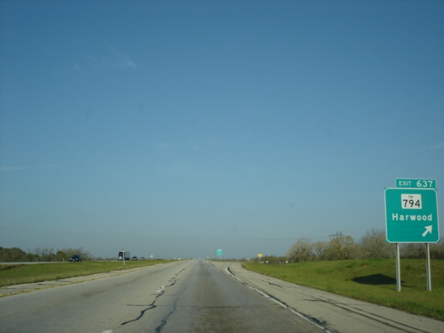
Interstate 10 West approaching Exit 637 - Farm to Market Road 794 - 1 mile. Harwood is located less than a mile to the north at U.S. 90. (Photo taken 3/17/05) |
 |
Interstate 10 West at Exit 637 - Farm to Market Road 794 - Harwood. Once again, motorists can get to Gonzales via this interchange. The county seat is ten miles to the south of Exit 637. (Photo taken 3/17/05) |
 |
Interstate 10 West approaching the diamond interchange at Exit 632 with U.S. 183. U.S. 90 is also mentioned here because it intersects U.S. 183 just north of the interstate. (Photo taken 3/17/05) |
 |
Interstate 10 West approaching Exit 632 - U.S. 90/U.S. 183 - 1/2 mile. (Photo taken 3/17/05) |
 |
Interstate 10 West at Exit 632 - U.S. 90/U.S. 183 - Luling/Lockhart. A couple of truck stops are located at this interchange. Lockhart is 17 miles to the north via U.S. 183. (Photo taken 3/17/05) |
 |
The second Luling interchange on Interstate 10 is Exit 628 for Texas 80, one mile ahead. (Photo taken 3/17/05) |
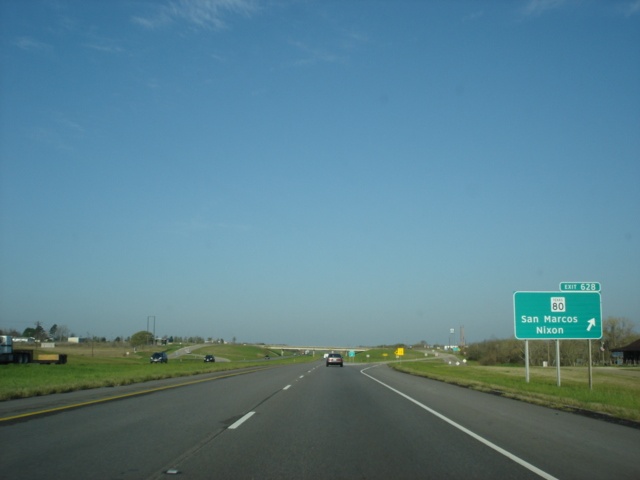 |
A Clearview font sign points the way to Exit 628 for Texas 80. San Marcos is located along Interstate 35 and is 25 miles to the northwest. Nixon is 28 miles to the south. (Photo taken 3/17/05) |
 |
Interstate 10 West approaching Exit 625 - Darst Field Road - 1 mile. (Photo taken 3/17/05) |
 |
Interstate 10 West approaching Darst Field Road, one-half mile. (Photo taken 3/17/05) |
 |
Interstate 10 West at Exit 625 - Darst Field Road. (Photo taken 3/17/05) |
 |
The next exit is Exit 621, Rest Area, two miles. The next rest area is in far eastern San Antonio at Exit 590. (Photo taken 3/17/05) |
 |
Interstate 10 West at Exit 621 - Rest Area. (Photo taken 3/17/05) |
 |
Interstate 10 West approaching Exit 620 - Farm to Market Road 1104 - 1 mile. The rest area is off to the right. (Photo taken 3/17/05) |
 |
As traffic from the rest area merges back onto the interstate, a one-half mile advance sign for Exit 620 appears. (Photo taken 3/17/05) |
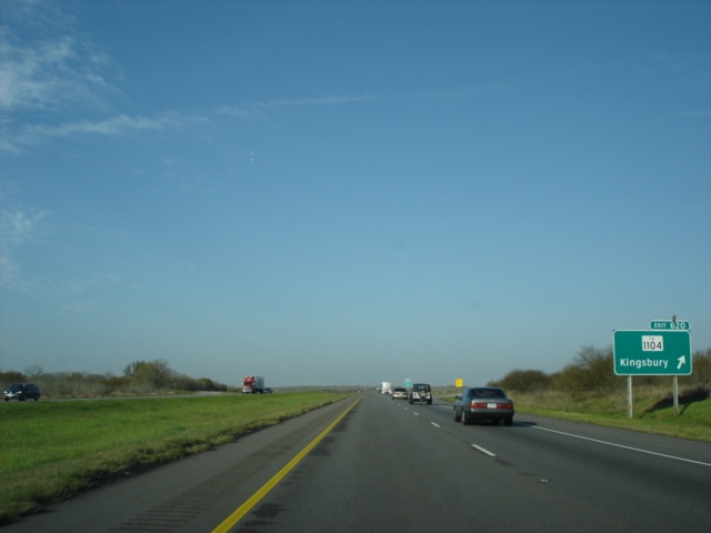 |
Interstate 10 West at Exit 620 - Farm to Market Road 1104 - Kingsbury, which is located three miles to the northwest along U.S. 90. (Photo taken 3/17/05) |
 |
Interstate 10 West approaching Exit 617 - Farm to Market Road 2438 - 1 mile. Minor construction on the shoulder narrowed traffic slightly through this overpass at Cross Road. (Photo taken 3/17/05) |
 |
Interstate 10 West approaching Exit 617, one-half mile, with a tractor-trailer blocking most of the sign. (Photo taken 3/17/05) |
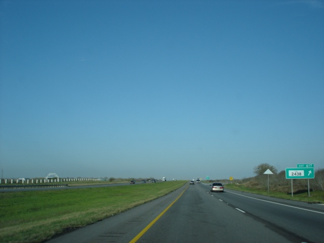 |
Interstate 10 West at Exit 617 - Farm to Market Road 2438. The farm to market road connects U.S. 90 in Kingsbury to Alternate U.S. 90. (Photo taken 3/17/05) |
 |
Interstate 10 West approaching Exit 612 - U.S. 90 - 1 mile. This is the final time the two routes intersect before rejoining at Exit 603. (Photo taken 3/17/05) |
 |
Exit 612 is the first of six exits to serve Seguin, population 22,011. The city is located just 40 miles from downtown San Antonio. (Photo taken 3/17/05) |
 |
Interstate 10 West at Exit 612 - U.S. 90 - Seguin. (Photo taken 3/17/05) |
 |
Interstate 10 West approaching unmarked Exit 610 - Texas 123 - 1 mile. (Photo taken 3/17/05) |
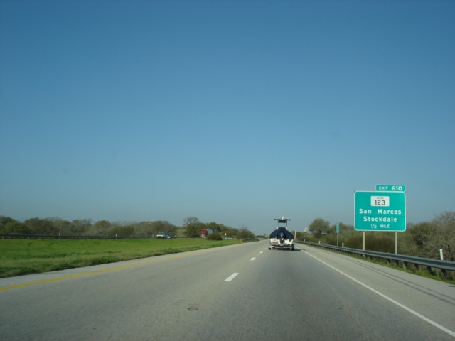 |
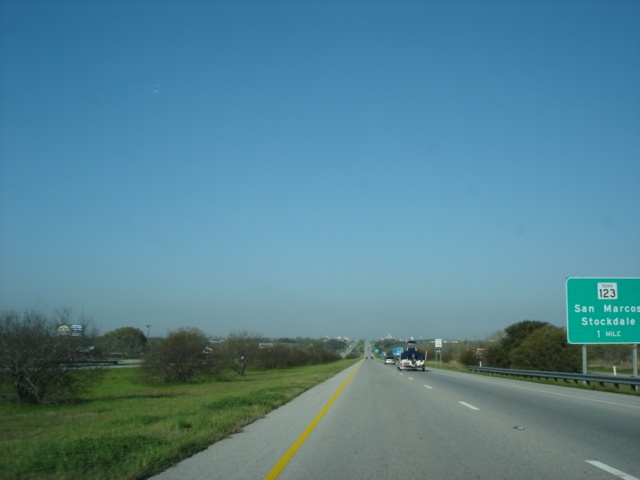
Interstate 10 West approaching Exit 610 - 1/2 mile. Texas 123 reaches San Marcos in 19 miles and Stockdale in 26 miles. (Photo taken 3/17/05) |
 |
Interstate 10 West reaches Exit 610 for Texas 123. The current route of Texas 123 bypasses the center of Seguin. The next exit serves the original Texas 123 route, now signed as a business route. (Photo taken 3/17/05) |
 |
Interstate 10 West approaching Exit 609 - Business Texas 123 - 3/4 mile. The state highway is known as Austin Street through Seguin. (Photo taken 3/17/05) |
 |
Interstate 10 West approaching Exit 609 - 1/2 mile. Traffic from the current route of Texas 123 prepares to merge onto the interstate. (Photo taken 3/17/05) |
 |
Interstate 10 West at Exit 609 - Business Texas 123 - Austin Street. (Photo taken 3/17/05) |
 |
Clearview font adorns the first sign of the upcoming Exit 607 interchange with Texas 46 and Farm to Market Road 78 in one mile. (Photo taken 3/17/05) |
 |
Interstate 10 West approaching Exit 607 - 1/2 mile. New Braunfels is known for its German culture and is just 10 miles to the northwest. (Photo taken 3/17/05) |
 |
Interstate 10 West reaches the now unmarked Exit 607 for Texas 46 and Farm to Market Road 78. The farm to market road begins its westbound journey here also. Lake McQueeney is just two miles to the west via Farm to Market Road 78 and Farm to Market Road 725. (Photo taken 3/17/05) |
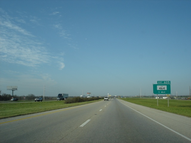 |
The next interchange is at Exit 605 for Farm to Market Road 464, which runs a distance of about two miles. (Photo taken 3/17/05) |
 |
Interstate 10 West approaching Exit 605 - 1/2 mile. (Photo taken 3/17/05) |
 |
Interstate 10 West at Exit 605 - Farm to Market Road 464. Less than a mile to the east is the eastbound beginning of Alternate U.S. 90. (Photo taken 3/17/05) |
 |
Interstate 10 West approaching the final Seguin exit. Exit 604 leads to Farm to Market Road 725. (Photo taken 3/17/05) |
 |
Interstate 10 West approaching Exit 604, one-quarter mile. Farm to Market Road 725 provides another connection between New Braunfels and Seguin. (Photo taken 3/17/05) |
 |
Interstate 10 West at Exit 604 - Farm to Market Road 725. (Photo taken 3/17/05) |
 |
As we leave Seguin behind and head towards San Antonio, Interstate 10 and U.S. 90 West, which rejoined the interstate at mile marker 603, draw closer to Exit 601 for Farm to Market Road 775. This sign appears to have been through a little wear and tear. (Photo taken 3/17/05) |
 |
Interstate 10 and U.S. 90 West approaching Exit 601 - 1/2 mile. (Photo taken 3/17/05) |
 |
Interstate 10 and U.S. 90 West at Exit 601 - Farm to Market Road 775 - New Berlin/La Vernia. We apologize for the blurry photo. (Photo taken 3/17/05) |
 |
Interstate 10 and U.S. 90 West approaching Exit 600 - Schwab Road - 1/2 mile. (Photo taken 3/17/05) |
 |
Interstate 10 and U.S. 90 West at Exit 600 - Schwab Road. Only 600 more miles to go until the New Mexico state line. (Photo taken 3/17/05) |
 |
Interstate 10 and U.S. 90 West approaching Exit 599 - Farm to Market Road 465 - 1/2 mile. Farm to Market Road 465 is a 3-mile highway connecting Interstate 10 to Farm to Market Road 78 in Marion. (Photo taken 3/17/05) |
 |
Interstate 10 and U.S. 90 West at Exit 599 - Farm to Market Road 465 - Marion. (Photo taken 3/17/05) |
 |
Interstate 10 and U.S. 90 West approach Exit 597, Santa Clara Road, one mile. (Photo taken 3/17/05) |
 |
Interstate 10 and U.S. 90 West approaching Exit 597, one-half mile. (Photo taken 3/17/05) |
 |
Interstate 10 and U.S. 90 West reach Exit 597 for Santa Clara Road. The Rivercity Raceway is located just off of this interchange. (Photo taken 3/17/05) |
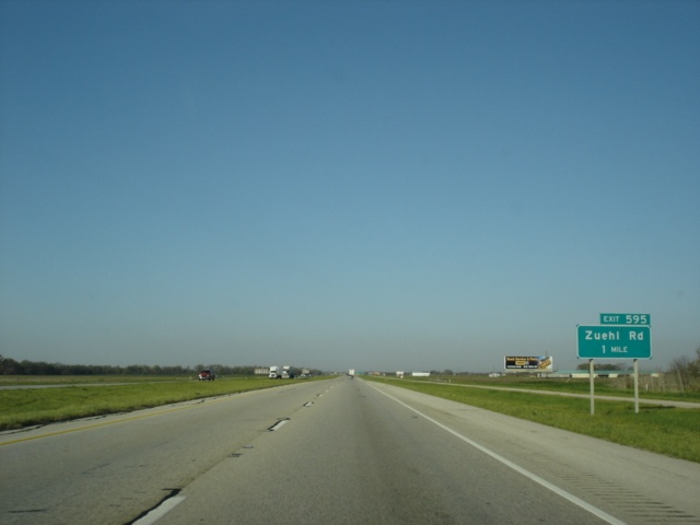 |
The final westbound exit in Guadalupe County is Exit 595, serving Zuehl Road. (Photo taken 3/17/05) |
 |
Interstate 10 and U.S. 90 West approaching Exit 595 - Zuehl Road - 1/2 mile. (Photo taken 3/17/05) |
 |
Interstate 10 and U.S. 90 West at Exit 595 - Zuehl Road. The two highways will cross Cibolo Creek and enter Bexar County in two miles. (Photo taken 3/17/05) |
 |
Interstate 10 and U.S. 90 West approaching unmarked Exit 593 - Farm to Market Road 2538 and Trainer Hale Road - 1 mile. (Photo taken 3/17/05) |
 |
Interstate 10 and U.S. 90 West are now in Bexar County as Exit 593 approaches in one-quarter mile. The speed limit remains 70 for cars for another ten miles. (Photo taken 3/17/05) |
 |
Interstate 10 and U.S. 90 West at Exit 593 - Farm to Market Road 2538/Trainer Hale Road. Farm to Market Road 2538 begins its southerly trek here and winds its way near the Cibolo Creek to Farm to Market Road 775 at New Berlin. (Photo taken 3/17/05) |
 |
Interstate 10 and U.S. 90 West approaching Exit 591 - Farm to Market Road 1518 - 1 mile. Schertz, a suburb of San Antonio, is located within five miles to the north of the upcoming exit. (Photo taken 3/17/05) |
 |
Interstate 10 and U.S. 90 West approaching Exit 591 - Farm to Market Road 1518 - 1/2 mile. Schertz is home for 26,463 people. (Photo taken 3/17/05) |
 |
Interstate 10 and U.S. 90 West at Exit 591 - Farm to Market Road 1518 - Schertz. The farm to market road connects Farm to Market Road 78 in Schertz to Loop 1604 near Adkins. Interstate 10 and U.S. 90 enter the city of San Antonio at the overpass ahead. (Photo taken 3/17/05) |
| Scenes Related to Interstate 10 | |
 |
Texas 36 North at Interstate 10 East in Sealy. Downtown Houston is a 50 mile drive from Sealy. (Photo taken 3/17/05) |
 |
Texas 36 South approaching Interstate 10 East. (Photo taken 3/16/05) |
 |
Texas 36 South at Interstate 10 East. Regular unleaded gas in Sealy was nearly $2/gallon on this early evening in mid March. (Photo taken 3/16/05) |
 |
Texas 36 North at Interstate 10 West. Personally, I think the bridge supports could use a bit more protection around them, but that's just me. (Photo taken 3/17/05) |
Highway Links
Texas:
AARoads.com (Andy Field/Alex Nitzman)
TxDOT Katy Freeway Construction Site
Page created: June 11, 2005
Last updated:
June 11, 2005